IMAGES TAKEN NEAR TO
Oswald Road, NEWPORT, NP20 2NB
Introduction
This page details the photographs taken nearby to Oswald Road, NP20 2NB by members of the Geograph project.
The Geograph project started in 2005 with the aim of publishing, organising and preserving representative images for every square kilometre of Great Britain, Ireland and the Isle of Man.

There are currently over 7.5m images from over14,400 individuals and you can help contribute to the project by visiting https://www.geograph.org.uk
Image Map
Images are licensed for reuse under creativecommons.org/licenses/by-sa/2.0
Notes
- Clicking on the map will re-center to the selected point.
- The higher the marker number, the further away the image location is from the centre of the postcode.
Image Listing (264 Images Found)
Images are licensed for reuse under creativecommons.org/licenses/by-sa/2.0
Image
Details
Distance
1
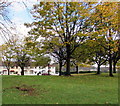
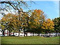
Autumn colours, Mendalgief Community Park, Newport
Viewed from Mendalgief Road on October 29th 2017. Baldwin Close houses are in the background.
Image: © Jaggery
Taken: 29 Oct 2017
0.01 miles
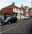
2
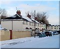
Baldwin Close, Newport
Baldwin Close is a row of six houses, opposite St Michaels RC Primary School. http://www.geograph.org.uk/photo/2207653
Image: © Jaggery
Taken: 24 Dec 2010
0.02 miles
3
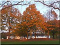
Autumn colours, Mendalgief Road
I had completely forgotten that I had submitted an almost identical picture exactly 7 years ago until, when preparing this one for submission, I came across http://www.geograph.org.uk/photo/1044209 .
Image: © Robin Drayton
Taken: 28 Oct 2015
0.02 miles
4
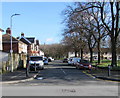
Jeddo Close towards Baldwin Close, Newport
From Mendalgief Road, Jeddo Close leads to Baldwin Close and St Michael's Roman Catholic Primary School.
Image: © Jaggery
Taken: 12 Feb 2020
0.02 miles
5
Autumn colour, Mendalgief Road
This small open space by Jeddo Close gives a complete contrast to the view opposite. http://www.geograph.org.uk/photo/1044199
Image: © Robin Drayton
Taken: 27 Oct 2008
0.03 miles
6
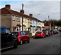
Jeddo Close houses and cars, Newport
Viewed from the corner of Mendalgief Road. All the houses are on this side of the road, opposite Mendalgief Community Park.
Image: © Jaggery
Taken: 29 Oct 2017
0.03 miles
7
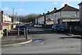
ENE along Lime Close, Newport
From Mendalgief Road along Lime Close towards a recreation ground.
Lime Close was originally Lime Street and formerly connected with Pottery Terrace.
Image: © Jaggery
Taken: 12 Feb 2020
0.05 miles
8
Mendalgief Road houses southeast of Lime Close, Newport
Between Lime Close (on the left) and Jeddo Close.
Image: © Jaggery
Taken: 12 Feb 2020
0.05 miles
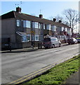
9
Lime Close houses and cars, Newport
The north side of Lime Close viewed from the Mendalgief Road end.
Image: © Jaggery
Taken: 29 Oct 2017
0.05 miles
10
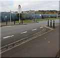
Mendalgief Road traffic calming, Newport
On the approach to the Jeddo Close junction, the width of Mendalgief Road is reduced to one lane for a few metres. Traffic on this side must give way to oncoming vehicles.
Image: © Jaggery
Taken: 29 Oct 2017
0.06 miles