IMAGES TAKEN NEAR TO
Marion Street, NEWPORT, NP20 2LY
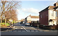
Introduction
This page details the photographs taken nearby to Marion Street, NP20 2LY by members of the Geograph project.
The Geograph project started in 2005 with the aim of publishing, organising and preserving representative images for every square kilometre of Great Britain, Ireland and the Isle of Man.

There are currently over 7.5m images from over14,400 individuals and you can help contribute to the project by visiting https://www.geograph.org.uk
Image Map
Images are licensed for reuse under creativecommons.org/licenses/by-sa/2.0
Notes
- Clicking on the map will re-center to the selected point.
- The higher the marker number, the further away the image location is from the centre of the postcode.
Image Listing (281 Images Found)
Images are licensed for reuse under creativecommons.org/licenses/by-sa/2.0
Image
Details
Distance
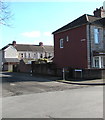
1
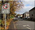
Marion Street traffic calming, Newport
For a few metres between Mendalgief Road and Oswald Road (ahead), the width of Marion Street is reduced to one lane. Traffic on this side must give way to oncoming vehicles.
Image: © Jaggery
Taken: 29 Oct 2017
0.04 miles
2
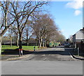
Deciduous trees alongside Marion Street, Newport
Viewed across Mendalgief Road in February 2020.
Image: © Jaggery
Taken: 12 Feb 2020
0.04 miles
3
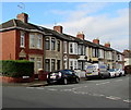
Row of houses, Oswald Road, Newport
Viewed from Alice Street. The row extends for 50 metres to the corner of Adeline Street.
Image: © Jaggery
Taken: 29 Oct 2017
0.04 miles
4
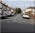
Oswald Road, Newport
From Alice Street along Oswald Road towards Adeline Street and Marion Street.
Image: © Jaggery
Taken: 29 Oct 2017
0.04 miles
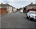
5
Marion Street towards Oswald Road, Newport
Viewed from Mendalgief Road. The houses in the background are in Oswald Road.
Image: © Jaggery
Taken: 12 Feb 2020
0.05 miles
6
Adeline Street, Newport
Concrete posts http://www.geograph.org.uk/photo/1601210 behind the camera prevent access to or from Mendalgief Road for motor vehicles.
Image: © Jaggery
Taken: 29 Oct 2017
0.05 miles
7
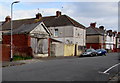
Derelict former shop, Adeline Street, Newport
The faded name H.A.SULLER is on the single-storey building located on the left here. http://www.geograph.org.uk/photo/5600047
Image: © Jaggery
Taken: 29 Oct 2017
0.06 miles
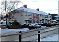
8
Baldwin Close, Newport
Baldwin Close is a row of six houses, opposite St Michaels RC Primary School. http://www.geograph.org.uk/photo/2207653
Image: © Jaggery
Taken: 24 Dec 2010
0.06 miles
9
Marion Street, Newport
Viewed from Mendalgief Road.
Image: © Jaggery
Taken: 30 Nov 2009
0.07 miles
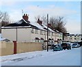
10
Marion Street houses, Newport
A row of houses painted in pastel shades in the middle section of Marion Street, opposite St Michaels RC Primary School. http://www.geograph.org.uk/photo/2207653
Image: © Jaggery
Taken: 24 Dec 2010
0.07 miles