IMAGES TAKEN NEAR TO
Adeline Street, NP20 2LX
Introduction
This page details the photographs taken nearby to Adeline Street, NP20 2LX by members of the Geograph project.
The Geograph project started in 2005 with the aim of publishing, organising and preserving representative images for every square kilometre of Great Britain, Ireland and the Isle of Man.

There are currently over 7.5m images from over14,400 individuals and you can help contribute to the project by visiting https://www.geograph.org.uk
Image Map
Images are licensed for reuse under creativecommons.org/licenses/by-sa/2.0
Notes
- Clicking on the map will re-center to the selected point.
- The higher the marker number, the further away the image location is from the centre of the postcode.
Image Listing (297 Images Found)
Images are licensed for reuse under creativecommons.org/licenses/by-sa/2.0
Image
Details
Distance
1
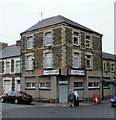
Docks Conservative Club, Pill, Newport
Located on the corner of Alice Street and Pottery Terrace, viewed across Alexandra Road.
Image: © Jaggery
Taken: 5 Oct 2009
0.03 miles
2

St Stephen's Church, Pill, Newport
Church occupying a triangle of land between Adeline Street, Alexandra Road and Pottery Terrace.
This view is from Alexandra Road, near the corner of Adeline Street. The building of the church took less than a year. The foundation stone was laid by Lord Tredegar on November 12 1883; the formal opening, a service of consecration, took place on October 16 1884.
See http://www.geograph.org.uk/photo/666387 for a view from a different angle.
Image: © Jaggery
Taken: 5 Oct 2009
0.03 miles
3
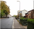
Adeline Street, Pill, Newport
The view from the Alexandra Road end. The trees on the left are at the perimeter of St Stephen's church.http://www.geograph.org.uk/photo/1975492
Image: © Jaggery
Taken: 5 Oct 2009
0.03 miles
4
Newport : west end of Adeline Street
Looking along Adeline Street from the Mendalgief Road end, across the intersection of Oswald Road ahead. On the left edge of the view is a small derelict single-storey building, perhaps once a corner shop. The faded name above the doorway is H A SULLER.
Image: © Jaggery
Taken: 23 Dec 2010
0.03 miles
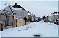
5

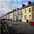
Long row of houses, Adeline Street, Newport
This row of houses on the south side of Adeline Street, between Oswald Road and Pottery Terrace, contains about two dozen houses, built before 1900 (probably late 19th century). An old-style white on dark blue street name sign is on the rightmost house, at the level of the base of the upstairs windows.
Image: © Jaggery
Taken: 23 Dec 2010
0.03 miles
6
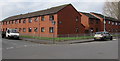
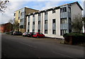
Tredegar Court, Pill, Newport
The Adeline Street (on the left) and Pottery Terrace sides of Tredegar Court retirement flats in the Pill area of Newport, built in 1980. Tredegar Court is managed by Melin Homes. New residents must be at least 55 years old.
Image: © Jaggery
Taken: 29 Oct 2017
0.04 miles
7
Yellow house, Alice Street, Newport
Opposite a speed bump.
Image: © Jaggery
Taken: 29 Oct 2017
0.05 miles
8
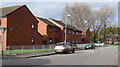
Flats on the north side of Adeline Street, Newport
Other sides of the flats are alongside Pottery Terrace and Marion Place.
Image: © Jaggery
Taken: 29 Oct 2017
0.05 miles
9
Pottery Terrace, Newport
This part of Pottery Terrace is between Adeline Street and Marion Street.
Tredegar Court flats http://www.geograph.org.uk/photo/5610868 are on the left.
Image: © Jaggery
Taken: 29 Oct 2017
0.06 miles
10
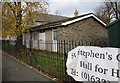
St Stephen's church hall, Pottery Terrace, Newport
In late October 2017 the banner shows that the hall is available for hire.
Image: © Jaggery
Taken: 29 Oct 2017
0.06 miles