IMAGES TAKEN NEAR TO
Jeddo Street, NEWPORT, NP20 2LQ
Introduction
This page details the photographs taken nearby to Jeddo Street, NP20 2LQ by members of the Geograph project.
The Geograph project started in 2005 with the aim of publishing, organising and preserving representative images for every square kilometre of Great Britain, Ireland and the Isle of Man.

There are currently over 7.5m images from over14,400 individuals and you can help contribute to the project by visiting https://www.geograph.org.uk
Image Map
Images are licensed for reuse under creativecommons.org/licenses/by-sa/2.0
Notes
- Clicking on the map will re-center to the selected point.
- The higher the marker number, the further away the image location is from the centre of the postcode.
Image Listing (268 Images Found)
Images are licensed for reuse under creativecommons.org/licenses/by-sa/2.0
Image
Details
Distance
1
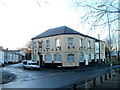
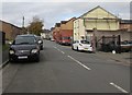
Royal Oak pub, Pill, Newport
Pub on the corner of Jeddo Street and Courtybella Terrace.
Image: © Jaggery
Taken: 15 Dec 2010
0.03 miles
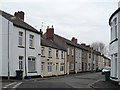
2
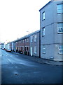
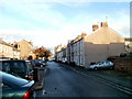
Jeddo Street, Newport
Houses on the south side of Jeddo Street, viewed from the edge of a 3-storey building on the corner of Pottery Terrace. There are no houses on the other side of Jeddo Street, which borders a recreation ground.
Image: © Jaggery
Taken: 15 Dec 2010
0.03 miles
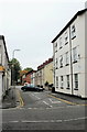
3
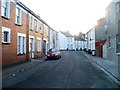
Baldwin Street, Newport
Viewed from the corner of Courtybella Terrace. Ahead, Baldwin Street bends to the right opposite the junction with James Street.
Image: © Jaggery
Taken: 15 Dec 2010
0.03 miles
4
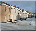
North side of Baldwin Street, Newport
Looking towards Courtybella Terrace from the corner of Pottery Terrace.
Image: © Jaggery
Taken: 24 Dec 2010
0.03 miles
5
James Street, Newport
From Alexandra Road along James Street towards Baldwin Street.
Image: © Jaggery
Taken: 29 Oct 2017
0.05 miles
6
Baldwin St, Pillgwenlly
An interesting contrast in this terrace. I would guess that the smaller houses were built first.
Image: © Robin Drayton
Taken: 18 Mar 2010
0.05 miles
7
New Street, Pill, Newport
New Street is a short cul-de-sac on the west side of Commercial Road. Viewed from the corner of Potter Street.
Image: © Jaggery
Taken: 5 Oct 2009
0.07 miles
8
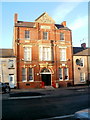
Former Pill library, Newport
The late Victorian building, on the north side of Temple Street, was originally a Newport library branch reading room, later upgraded to a branch lending library. In January 2009, library services were transferred to a new branch in Commercial Road, http://www.geograph.org.uk/photo/1975553 The building is now the headquarters of Pillgwenlly Community First.
Inscribed in stone above the top floor central window is
KNOWLEDGE IS POWER
Above that, 1889 is inscribed in the pediment (topmost triangular stone).
Image: © Jaggery
Taken: 15 Dec 2010
0.07 miles
9
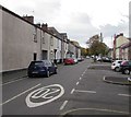
Temple Street, Newport
The view east along Temple Street, looking towards Commercial Road.
Image: © Jaggery
Taken: 15 Dec 2010
0.07 miles
10
Temple Street, Pill, Newport
From Commercial Road behind the camera, Temple Street extends for 150 metres to the edge of a recreation ground. The 20mph speed limit on Commercial Road increases to 30mph ahead.
Image: © Jaggery
Taken: 29 Oct 2017
0.07 miles