IMAGES TAKEN NEAR TO
Brunel Street, NEWPORT, NP20 2JT
Introduction
This page details the photographs taken nearby to Brunel Street, NP20 2JT by members of the Geograph project.
The Geograph project started in 2005 with the aim of publishing, organising and preserving representative images for every square kilometre of Great Britain, Ireland and the Isle of Man.

There are currently over 7.5m images from over14,400 individuals and you can help contribute to the project by visiting https://www.geograph.org.uk
Image Map
Images are licensed for reuse under creativecommons.org/licenses/by-sa/2.0
Notes
- Clicking on the map will re-center to the selected point.
- The higher the marker number, the further away the image location is from the centre of the postcode.
Image Listing (384 Images Found)
Images are licensed for reuse under creativecommons.org/licenses/by-sa/2.0
Image
Details
Distance
1
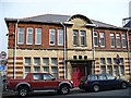
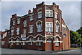
Former Police Station, Alexandra Road
Image: © Robin Drayton
Taken: 22 Jan 2008
0.02 miles
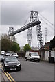
2
The western anchorage of Newport Transporter Bridge, 1996
For a similar view in 2012 see http://www.geograph.org.uk/photo/2988139 .
Image: © Robin Drayton
Taken: Unknown
0.02 miles
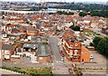
3
Coomassie Street, Newport
Coomassie Street in Newport is dominated in the background by the Transporter Bridge.
Image: © Philip Halling
Taken: 11 May 2013
0.03 miles
4
Warws hanesyddol / Historic warehouse
This warehouse is one of a number of fine, but rather neglected, buildings in the area. The sign by the door reads "G.W. Elliott & Son Ships Provisions & Bonded Stores"
Image: © Ceri Thomas
Taken: 1 Jun 2009
0.03 miles
5
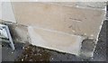
Ordnance Survey Cut Mark
This OS cut mark can be found on the Old Police Station, Alexandra Road. It marks a point 8.932m above mean sea level.
Image: © Adrian Dust
Taken: 9 Jun 2018
0.04 miles
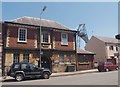
6
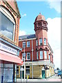
The Waterloo, Newport
Grade II listed building with distinctive corner tower and ogee cap. This was formerly a dockers pub but is now trading as a hotel.
Image: © Colin Smith
Taken: 25 Jul 2009
0.04 miles
7
West of England public house, Newport
Image: © Nick Mutton 01329 000000
Taken: 29 Jun 2010
0.04 miles
8
Coomassie Street, Newport
The Transporter Bridge dominates this view of Coomassie Street, from the corner of Alexandra Road.
Image: © Jaggery
Taken: 30 Nov 2009
0.04 miles
9
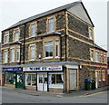
Two shops, Alexandra Road, Newport
On the corner of Brunel Street and Alexandra Road are Made 4U baguettes, and B&T Parrots whose sign above the doorway has "Pets and Aquatic Warehouse".
Image: © Jaggery
Taken: 5 Oct 2009
0.04 miles
10
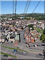
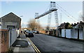
View of Pill (Newport) from the transporter bridge
The cables of the bridge run down to the anchoring point.
Image: © Gareth James
Taken: 30 Aug 2010
0.04 miles