IMAGES TAKEN NEAR TO
Mill Parade, NEWPORT, NP20 2JS
Introduction
This page details the photographs taken nearby to Mill Parade, NP20 2JS by members of the Geograph project.
The Geograph project started in 2005 with the aim of publishing, organising and preserving representative images for every square kilometre of Great Britain, Ireland and the Isle of Man.

There are currently over 7.5m images from over14,400 individuals and you can help contribute to the project by visiting https://www.geograph.org.uk
Image Map
Images are licensed for reuse under creativecommons.org/licenses/by-sa/2.0
Notes
- Clicking on the map will re-center to the selected point.
- The higher the marker number, the further away the image location is from the centre of the postcode.
Image Listing (343 Images Found)
Images are licensed for reuse under creativecommons.org/licenses/by-sa/2.0
Image
Details
Distance
1
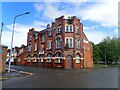
West of England Tavern
At the junction of Brunel Street and Mill Street, opposite the Newport Transporter Bridge
Image: © Eirian Evans
Taken: 24 May 2021
0.00 miles
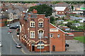
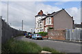
2
West of England Tavern, Newport
Located at 42 Mill Parade, on the corner of Brunel Street. In addition to a bar serving a selection of lagers and real ales, accommodation is available, and two function rooms are for hire.
Visible behind the building are the support cables of the west side of the Transport Bridge. The cables are fixed to two buttresses in Brunel Street.
Image: © Jaggery
Taken: 5 Oct 2009
0.01 miles
3
West of England Tavern - Newport
An interesting name for this public house that is in Wales! Seen from the Newport Transporter Bridge
Image: © Chris Allen
Taken: 18 Aug 2013
0.01 miles
4
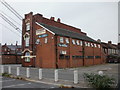
Waterloo Hotel, Pillgwenlly
The Waterloo Hotel is listed Grade II and is a good example of an early 20th century public house with a surviving interior of exceptional quality. The corner of the building has an exceptional cantilevered octagonal clock tower rising to four stories in height with pierced terracotta strapwork chamber to the top storey. The whole is set beneath a roof clad in fishscale clay tiling. The clock faces south to the docks serving to reinforce the historic dependency between the two.
For a close look at the top of the clock tower see http://www.geograph.org.uk/photo/5571887 .
Image: © Robin Drayton
Taken: 22 Jan 2008
0.01 miles
5
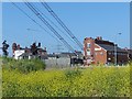
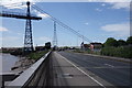
At the western end of Newport Transporter Bridge
This view is taken from near to the Transporter Bridge visitor centre http://www.geograph.org.uk/photo/1964726 .
The support cables from the top of the bridge drop down across the A48 to the western anchorage point.
On the left is the Waterloo Hotel http://www.geograph.org.uk/photo/666381 and on the right is the West of England public house http://www.geograph.org.uk/photo/1938745 .
Image: © Robin Drayton
Taken: 13 Jul 2013
0.01 miles
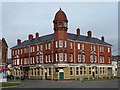
6
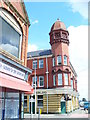
The Waterloo, Newport
Grade II listed building with distinctive corner tower and ogee cap. This was formerly a dockers pub but is now trading as a hotel.
Image: © Colin Smith
Taken: 25 Jul 2009
0.02 miles
7
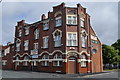
West of England public house, Newport
Image: © Nick Mutton 01329 000000
Taken: 29 Jun 2010
0.02 miles
8
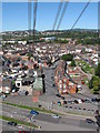
View of Pill (Newport) from the transporter bridge
The cables of the bridge run down to the anchoring point.
Image: © Gareth James
Taken: 30 Aug 2010
0.02 miles
9
Watch House Parade, Newport
Image: © Nick Mutton 01329 000000
Taken: 29 Jun 2010
0.02 miles
10
The Transporter Bridge
The supporting cables for the bridge cross Usk Way and are anchored many yards away from the base of the towers.
Image: © Peter Jeffery
Taken: 10 Jul 2015
0.03 miles