IMAGES TAKEN NEAR TO
Mill Parade, NEWPORT, NP20 2JQ
Introduction
This page details the photographs taken nearby to Mill Parade, NP20 2JQ by members of the Geograph project.
The Geograph project started in 2005 with the aim of publishing, organising and preserving representative images for every square kilometre of Great Britain, Ireland and the Isle of Man.

There are currently over 7.5m images from over14,400 individuals and you can help contribute to the project by visiting https://www.geograph.org.uk
Image Map
Images are licensed for reuse under creativecommons.org/licenses/by-sa/2.0
Notes
- Clicking on the map will re-center to the selected point.
- The higher the marker number, the further away the image location is from the centre of the postcode.
Image Listing (278 Images Found)
Images are licensed for reuse under creativecommons.org/licenses/by-sa/2.0
Image
Details
Distance
1
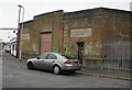
Former electricity substation, Pill, Newport
Located in Mill Parade, next to John's Electrics. http://www.geograph.org.uk/photo/1964646
Image: © Jaggery
Taken: 5 Oct 2009
0.01 miles
2
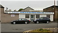
John's Electrics, Pill, Newport
John's Electrics (1989) Ltd is located on Mill Parade next door to a former electricity substation http://www.geograph.org.uk/photo/1964640.
The firm specialises in design, sales, installation and servicing of electrical equipment for the catering industry.
Image: © Jaggery
Taken: 5 Oct 2009
0.01 miles
3
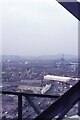
View towards Mill Parade from Newport Transporter Bridge walkway
Image: © Richard Park
Taken: Unknown
0.02 miles
4
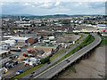
The view to the north from Newport Transporter Bridge
The road in the foreground is the A48, Southern Distributor Road.
The original road here was turned in to a dual carriageway by constructing a second carriageway on the landward side of the road on stilts along the river bank.
For a similar view taken in 1996 see http://www.geograph.org.uk/photo/5213396 .
Image: © Robin Drayton
Taken: 4 Jun 2012
0.04 miles
5
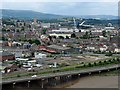
A view over Newport City centre.
Taken from the Transporter Bridge.
The road in the foreground is the A48, Southern Distributor Road.
The original road here was turned in to a dual carriageway by constructing a road on stilts along the bank of the River Usk.
The straight road to the left of centre is Commercial Street.
Image: © Robin Drayton
Taken: 4 Jun 2012
0.04 miles
6
Mill Parade, Newport
Viewed across Alexandra Road from the corner of Courtybella Terrace. Alexandra Court http://www.geograph.org.uk/photo/5606746 is on the right.
Image: © Jaggery
Taken: 29 Oct 2017
0.04 miles
7

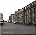
Usk Side Business Park, Newport
The recently repainted building is on Church Street, on the northern side of Usk Way. The inscription at third floor level is USKSIDE IRON WORKS. This http://www.geograph.org.uk/photo/1964330 is how the building looked two years earlier, in October 2009.
Image: © Jaggery
Taken: 16 Oct 2011
0.05 miles
8
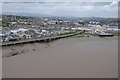
Newport viewed from the Transporter Bridge
The city of Newport viewed from the boom of the transporter bridge which crosses the River Usk.
Image: © Philip Halling
Taken: 11 May 2013
0.05 miles
9
Church Street, Pill, Newport
The view from the southern end of Commercial Road.
Image: © Jaggery
Taken: 5 Oct 2009
0.06 miles
10
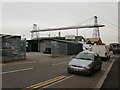
Laurence Bailey, Pill, Newport
Vehicle accident repair centre on Mill Parade. One of the firm's courtesy cars is
in view.
In this part of Newport, the 74 metre high (242 feet) Transporter Bridge is a dominant presence.
Image: © Jaggery
Taken: 5 Oct 2009
0.07 miles