1
Coomassie Street, Newport
The Transporter Bridge dominates this view of Coomassie Street, from the corner of Alexandra Road.
Image: © Jaggery
Taken: 30 Nov 2009
0.02 miles
2
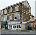
Two shops, Alexandra Road, Newport
On the corner of Brunel Street and Alexandra Road are Made 4U baguettes, and B&T Parrots whose sign above the doorway has "Pets and Aquatic Warehouse".
Image: © Jaggery
Taken: 5 Oct 2009
0.02 miles
3
Ordnance Survey Cut Mark
This OS cut mark can be found on the Old Police Station, Alexandra Road. It marks a point 8.932m above mean sea level.
Image: © Adrian Dust
Taken: 9 Jun 2018
0.03 miles
4
Alexandra Dock Post Office, Newport
The post office at 98 Alexandra Road is next door to Made 4 U baguettes shop.
Image: © Jaggery
Taken: 20 Jul 2014
0.04 miles
5
Old fashioned kiosk shop front on corner of Alexandra Road
Image: © Nick Mutton 01329 000000
Taken: 29 Jun 2010
0.04 miles
6
Corner of Milman Street and Wolseley Street, Newport
The houses are on Milman Street. Visible behind Wolseley Street is the Transporter Bridge. http://www.geograph.org.uk/photo/1624855
Image: © Jaggery
Taken: 23 Dec 2010
0.04 miles
7
Newport : Wolseley Street between Milman Street and Wolseley Close
Houses on the east side of the street. In the distance is the top of the Transporter Bridge. http://www.geograph.org.uk/photo/1624855
Image: © Jaggery
Taken: 23 Dec 2010
0.04 miles
8
Wolseley Close, Newport
A cul-de-sac of eight houses, viewed from Wolseley Street, opposite the turning for Wingate Street. The houses at right angles in the distance are on Alexandra Road. Peeping above the roof is the top of the Transporter Bridge. http://www.geograph.org.uk/photo/1624855
Image: © Jaggery
Taken: 23 Dec 2010
0.04 miles
9
Newport : Wolseley Street from the north
The view along Wolseley Street from the corner of Alice Street, looking past the Milman Street intersection, marked by a thin grey horizontal line through the snow.
Image: © Jaggery
Taken: 23 Dec 2010
0.04 miles
10
Warws hanesyddol / Historic warehouse
This warehouse is one of a number of fine, but rather neglected, buildings in the area. The sign by the door reads "G.W. Elliott & Son Ships Provisions & Bonded Stores"
Image: © Ceri Thomas
Taken: 1 Jun 2009
0.04 miles


