1
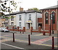
Jamia Mosque original building, Newport
Located at 183 Commercial Road, near the George Street junction.
This is the original mosque, later extended by the building of the much larger
mosque on the right. http://www.geograph.org.uk/photo/1789236
Image: © Jaggery
Taken: 5 Oct 2009
0.02 miles
2
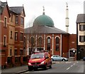
Jamia Mosque, Newport
Located at the north end of Commercial Road. It is connected to the original mosque http://www.geograph.org.uk/photo/1789230 on the left.
Image: © Jaggery
Taken: 5 Oct 2009
0.02 miles
3
Mountjoy Christian Fellowship, Newport
Car park and church building viewed from Alma Street. There is a pedestrian entrance to the far side of the church, from Mountjoy Street.
Image: © Jaggery
Taken: 15 Dec 2010
0.02 miles
4
Mountjoy Road, Newport
Viewed from the corner of Mountjoy Place and Mountjoy Street. The large building on the left is the central police station. http://www.geograph.org.uk/photo/1461471
Image: © Jaggery
Taken: 18 Dec 2010
0.02 miles
5
Mountjoy Street entrance to Mountjoy Christian Fellowship, Newport
The church car park is behind the building, accessed from Alma Street. http://www.geograph.org.uk/photo/2200208
Image: © Jaggery
Taken: 18 Dec 2010
0.02 miles
6
A1 Shine, Newport
Car wash premises, Mountjoy Road.
Image: © Jaggery
Taken: 25 Dec 2010
0.02 miles
7
Dome and minaret, Commercial Road, Newport
Jamia Mosque http://www.geograph.org.uk/photo/1789236 viewed from Ruperra Street.
Image: © Jaggery
Taken: 24 Feb 2011
0.02 miles
8
Clytha Crescent
These houses were built in the 1870s. This is the right hand half of a crescent of 16 houses which is bisected by a road.
Image: © Robin Drayton
Taken: 18 Feb 2008
0.04 miles
9
Herbert Walk, Newport
Houses in Herbert Walk are arranged around several arms radiating from the north side of Alma Street. The houses along this arm are numbered 457-482. The numbering scheme is unusual in that the sequence of numbers is shared by several streets, built at about the same time. For example, nearby Kirby Lane has about 20 properties, all numbered in the low 300s.
Image: © Jaggery
Taken: 15 Dec 2010
0.04 miles
10
Pigeons find the warm spot, Alma Street, Newport
Several dozen pigeons huddle together for warmth on a cold December day. They have chosen the only thawed section of a snowy roof. The building is a group of flats, adjacent to the car park in front of Mountjoy Christian Fellowship. http://www.geograph.org.uk/photo/2200208
Image: © Jaggery
Taken: 17 Dec 2010
0.04 miles


