IMAGES TAKEN NEAR TO
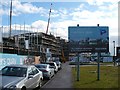
East Dock Road, NEWPORT, NP20 2HN
Introduction
This page details the photographs taken nearby to East Dock Road, NP20 2HN by members of the Geograph project.
The Geograph project started in 2005 with the aim of publishing, organising and preserving representative images for every square kilometre of Great Britain, Ireland and the Isle of Man.

There are currently over 7.5m images from over14,400 individuals and you can help contribute to the project by visiting https://www.geograph.org.uk
Image Map
Images are licensed for reuse under creativecommons.org/licenses/by-sa/2.0
Notes
- Clicking on the map will re-center to the selected point.
- The higher the marker number, the further away the image location is from the centre of the postcode.
Image Listing (184 Images Found)
Images are licensed for reuse under creativecommons.org/licenses/by-sa/2.0
Image
Details
Distance
1
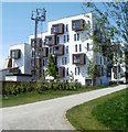
Construction of Mariners Quay
A large housing development alongside the River Usk on the site of Old Town Dock.
The housing is being designed to achieve a level five rating under the Code for Sustainable Homes which will make it the largest scheme in Wales to achieve this rating.
Image: © Robin Drayton
Taken: 16 Feb 2010
0.01 miles
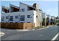
2

Mariners Quay Housing, Newport
Situated on East Dock Road, Mariners Quay is a 21st century development of 87 apartments, 15 mews and terraced houses alongside the west bank of the River Usk.
This is part of the regeneration of the Old Town Dock area of Newport.
Image: © Robin Drayton
Taken: 15 Jun 2013
0.01 miles
3
Early 21st century housing, Mariners Quay, Newport
A view along East Dock Road.
Image: © Jaggery
Taken: 25 Apr 2011
0.05 miles
4
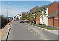
A view NE along East Dock Road, Newport
A late April 2011 view along the western edge of the Mariners Quay new housing development.
Image: © Jaggery
Taken: 25 Apr 2011
0.05 miles
5
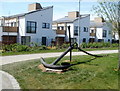
Anchor alongside a riverside walk on the west bank of the Usk, Newport
The anchor is a reminder that the banks of the River Usk in Newport were formerly
very busy with a wide variety of occupations connected with the sea.
Image: © Jaggery
Taken: 25 Apr 2011
0.05 miles
6
East Dock Road housing viewed from a riverside path, Newport
Recently-built housing viewed from the west bank of the River Usk.
Image: © Jaggery
Taken: 25 Apr 2011
0.05 miles
7

Gardens at Old Town Dock
Gardens and property developments at Old Town Dock in Newport.
Image: © Philip Halling
Taken: 11 May 2013
0.05 miles
8
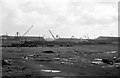
Scrap locomotives at Pill, Newport ? 1963
The area is now a housing estate.
Image: © Alan Murray-Rust
Taken: 9 Mar 1963
0.05 miles
9

Scrap locomotives at Pill, Newport ? 1963
Former GWR locomotives waiting to be moved into the main Cashmore's scrapyard.
Image: © Alan Murray-Rust
Taken: 9 Mar 1963
0.05 miles
10

Mariners Quay, East Dock Road, Newport
Access along East Dock Road is only to the business premises on the west side.
The south and east side of the road are the Mariners Quay development site. Construction work began in July 2009. There will be 86 one and two bedroom apartments (completion expected summer 2010) and 15 houses ranging from two to four bedrooms (completion expected early 2011).
Much of the energy to power the homes will be produced on-site by a biomass power plant, which burns wood chip fuel, and by solar panels on the roof. There will also be a rainwater recycling facility, to be used for toilets, washing machines and dishwashers.
Image: © Jaggery
Taken: 30 Nov 2009
0.06 miles