IMAGES TAKEN NEAR TO
Wingate Street, NEWPORT, NP20 2HL
Introduction
This page details the photographs taken nearby to Wingate Street, NP20 2HL by members of the Geograph project.
The Geograph project started in 2005 with the aim of publishing, organising and preserving representative images for every square kilometre of Great Britain, Ireland and the Isle of Man.

There are currently over 7.5m images from over14,400 individuals and you can help contribute to the project by visiting https://www.geograph.org.uk
Image Map
Images are licensed for reuse under creativecommons.org/licenses/by-sa/2.0
Notes
- Clicking on the map will re-center to the selected point.
- The higher the marker number, the further away the image location is from the centre of the postcode.
Image Listing (327 Images Found)
Images are licensed for reuse under creativecommons.org/licenses/by-sa/2.0
Image
Details
Distance
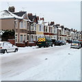
1
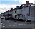
Houses on the south side of Wingate Street, Newport
Viewed across Mendalgief Road looking along Wingate Street towards Wolseley Street.
Image: © Jaggery
Taken: 20 Jul 2014
0.03 miles
2
Corner of Milman Street and Wolseley Street, Newport
The houses are on Milman Street. Visible behind Wolseley Street is the Transporter Bridge. http://www.geograph.org.uk/photo/1624855
Image: © Jaggery
Taken: 23 Dec 2010
0.03 miles
3
Newport : Wolseley Street between Milman Street and Wolseley Close
Houses on the east side of the street. In the distance is the top of the Transporter Bridge. http://www.geograph.org.uk/photo/1624855
Image: © Jaggery
Taken: 23 Dec 2010
0.03 miles
4
Wolseley Close, Newport
A cul-de-sac of eight houses, viewed from Wolseley Street, opposite the turning for Wingate Street. The houses at right angles in the distance are on Alexandra Road. Peeping above the roof is the top of the Transporter Bridge. http://www.geograph.org.uk/photo/1624855
Image: © Jaggery
Taken: 23 Dec 2010
0.03 miles
5
Newport : Wolseley Street from the north
The view along Wolseley Street from the corner of Alice Street, looking past the Milman Street intersection, marked by a thin grey horizontal line through the snow.
Image: © Jaggery
Taken: 23 Dec 2010
0.03 miles
6
Mendalgief Road houses southeast of Milman Street, Newport
Extending from the corner of Milman Street on the left towards the corner of Wingate Street.
Image: © Jaggery
Taken: 12 Feb 2020
0.03 miles
7
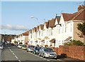
Mendalgief Road, Newport
Houses on the east side of Mendalgief Road.
Image: © Jaggery
Taken: 30 Nov 2009
0.04 miles
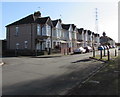
8
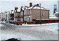
Milman Street, Newport
Houses on the north side of Milman Street, viewed from Mendalgief Road.
Image: © Jaggery
Taken: 30 Nov 2009
0.04 miles
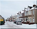
9
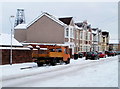
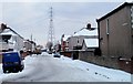
North side of Milman Street, Newport
Houses on the north side of the street, viewed from the Mendalgief Road end. After a moderate snowfall three days earlier, all the main roads in Newport have been cleared of snow, but most side roads, as here, remain covered in snow.
Image: © Jaggery
Taken: 23 Dec 2010
0.04 miles
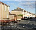
10
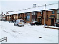
South side of Milman Street, Newport
Houses on the south side of the street, viewed from the Mendalgief Road end. After a moderate snowfall three days earlier, main roads in Newport have been cleared of snow, but most side roads, as here, remain covered in snow.
Image: © Jaggery
Taken: 23 Dec 2010
0.04 miles