IMAGES TAKEN NEAR TO
Alicia Crescent, NEWPORT, NP20 2GS
Introduction
This page details the photographs taken nearby to Alicia Crescent, NP20 2GS by members of the Geograph project.
The Geograph project started in 2005 with the aim of publishing, organising and preserving representative images for every square kilometre of Great Britain, Ireland and the Isle of Man.

There are currently over 7.5m images from over14,400 individuals and you can help contribute to the project by visiting https://www.geograph.org.uk
Image Map
Images are licensed for reuse under creativecommons.org/licenses/by-sa/2.0
Notes
- Clicking on the map will re-center to the selected point.
- The higher the marker number, the further away the image location is from the centre of the postcode.
Image Listing (123 Images Found)
Images are licensed for reuse under creativecommons.org/licenses/by-sa/2.0
Image
Details
Distance
1
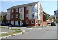
Alicia Crescent, Newport
Recently-built housing on the SW side of Alicia Crescent, viewed across East Dock Road. Part of the Mariners Quay development.
Image: © Jaggery
Taken: 25 Apr 2011
0.02 miles
2
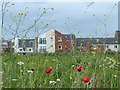
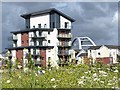
Alexandra Gate Housing, Newport
Situated on East Dock Road, Alexandra Gate is a 21st century housing development.
This is part of the regeneration of the Old Town Dock area of Newport.
Viewed across undeveloped land which has been screened with wild flowers.
Image: © Robin Drayton
Taken: 15 Jun 2013
0.04 miles
3
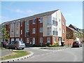
Alicia Way, Newport
Recently-built housing on the SW side of Alicia Way, viewed across East Dock Road.
Part of the Mariners Quay development.
Image: © Jaggery
Taken: 25 Apr 2011
0.04 miles
4

Development site
Hoarding promoting the Old Town Dock area of Newport for redevelopment.
Image: © Philip Halling
Taken: 11 May 2013
0.05 miles
5

Alexandra Gate Housing, Newport
Situated on East Dock Road, Alexandra Gate is a 21st century housing development.
This is part of the regeneration of the Old Town Dock area of Newport.
Viewed across undeveloped land which has been screened with wild flowers.
Image: © Robin Drayton
Taken: 15 Jun 2013
0.05 miles
6
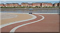
Viewing area on the west bank of the River Usk, Newporr
Part of a long riverside walk on the west bank of the Usk. This section of the walk is near Mariners Quay houses.
Image: © Jaggery
Taken: 25 Apr 2011
0.06 miles
7
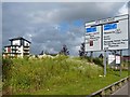
Road sign, Old Town Dock, Newport
The name on the road sign is a reminder of the past.
Newport's Town Dock on the west side of the River Usk opened in 1842 and was filled in 1930.
An extensive regeneration project has been undertaken in this and the surrounding industrial area in recent years.
A screening bank planted with wild flowers has been constructed alongside part of the remaining area that is still undeveloped.
Image: © Robin Drayton
Taken: 15 Jun 2013
0.07 miles
8
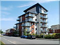
Penner Court, Ariel Close, Newport
Multi-storey block of flats built 2009. Part of the Mariners Quay development.
Image: © Jaggery
Taken: 25 Apr 2011
0.07 miles
9
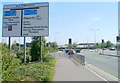
Southern end of Usk Way, Newport
Usk Way (A4042) approaches the A48 junction.
Image: © Jaggery
Taken: 25 Apr 2011
0.08 miles
10
Alexandra Gate Housing, Newport
Situated on East Dock Road, Alexandra Gate is a 21st century housing development.
This is part of the regeneration of the Old Town Dock area of Newport.
Viewed across undeveloped land which has been screened with wild flowers.
The upper structure of the City Bridge http://www.geograph.org.uk/photo/1140452 can be seen in the background.
Image: © Robin Drayton
Taken: 15 Jun 2013
0.08 miles