1
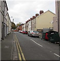
New Street, Newport
Dead end street on the west side of Commercial Road in the Pill area of Newport.
Image: © Jaggery
Taken: 29 Oct 2017
0.01 miles
2
New Street, Pill, Newport
New Street is a short cul-de-sac on the west side of Commercial Road. Viewed from the corner of Potter Street.
Image: © Jaggery
Taken: 5 Oct 2009
0.03 miles
3
Former Pill library, Newport
The late Victorian building, on the north side of Temple Street, was originally a Newport library branch reading room, later upgraded to a branch lending library. In January 2009, library services were transferred to a new branch in Commercial Road, http://www.geograph.org.uk/photo/1975553 The building is now the headquarters of Pillgwenlly Community First.
Inscribed in stone above the top floor central window is
KNOWLEDGE IS POWER
Above that, 1889 is inscribed in the pediment (topmost triangular stone).
Image: © Jaggery
Taken: 15 Dec 2010
0.03 miles
4
Temple Street, Newport
The view east along Temple Street, looking towards Commercial Road.
Image: © Jaggery
Taken: 15 Dec 2010
0.03 miles
5
Former Pillgwenlly Library, Temple Street, Newport
This building was refurbished in 2011 to become a resource centre offering vocational training and housing a number of social enterprises, including a child care facility.
For a close view of the pediment see this http://www.geograph.org.uk/photo/5303002.
For a view in 2010 see http://www.geograph.org.uk/photo/2199751.
Image: © Robin Drayton
Taken: 2 Mar 2017
0.04 miles
6
Pediment on the former Pillgwenlly Library, Newport
The English phrase “knowledge is power” comes from the Latin "scientia potentia est" and is commonly attributed to Sir Francis Bacon (1561-1626).
See this http://www.geograph.org.uk/photo/5302999 for the building as a whole.
Image: © Robin Drayton
Taken: 2 Mar 2017
0.04 miles
7
Courtybella Terrace, Pillgwenlly
Now a residential property, Cumberland House was erected in 1891.
Image: © Robin Drayton
Taken: 18 Mar 2010
0.04 miles
8
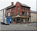
South Wales Locksmiths, Newport
Locksmiths and architectural ironmongers, at 132 Commercial Road, on the corner of Temple Street. The business was founded in 1979.
Image: © Jaggery
Taken: 5 Oct 2009
0.04 miles
9
Shops on the corner of Temple Street, Pill
Behind Taj Balti is South Wales Locksmiths, on the corner of Commercial Road and Temple Street. Viewed from Commercial Road.
On the edge of the view is part of the derelict former The Kings Arms pub. http://www.geograph.org.uk/photo/1792106
Image: © Jaggery
Taken: 5 Oct 2009
0.04 miles
10
Overlooking Pillgwenlly towards George Street Bridge
Taken in 1996 from Newport Transporter Bridge.
Image: © Robin Drayton
Taken: Unknown
0.05 miles


