IMAGES TAKEN NEAR TO
Albion Close, NEWPORT, NP20 2GG
Introduction
This page details the photographs taken nearby to Albion Close, NP20 2GG by members of the Geograph project.
The Geograph project started in 2005 with the aim of publishing, organising and preserving representative images for every square kilometre of Great Britain, Ireland and the Isle of Man.

There are currently over 7.5m images from over14,400 individuals and you can help contribute to the project by visiting https://www.geograph.org.uk
Image Map
Images are licensed for reuse under creativecommons.org/licenses/by-sa/2.0
Notes
- Clicking on the map will re-center to the selected point.
- The higher the marker number, the further away the image location is from the centre of the postcode.
Image Listing (267 Images Found)
Images are licensed for reuse under creativecommons.org/licenses/by-sa/2.0
Image
Details
Distance
1
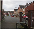
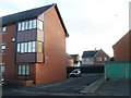
Albion Close, Newport
Modern housing viewed from the edge of Commercial Road in the Pill area of Newport.
Image: © Jaggery
Taken: 29 Oct 2017
0.02 miles
2
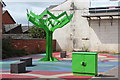
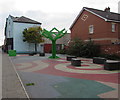
Tree sculpture, Pillgwenlly, Newport
Green metal tree and grey cuboid benches by artist Martin Heron on a coloured square on Commercial Road at its junction with Frederick Street. The upper surfaces of the tree's flat branches are shaped into steps, with figures in silhouette ascending or descending some of the steps. This is a reminder of a bridge that once spanned railway tracks in the vicinity. The artwork is one of three commissioned by the Pillgwenlly Regeneration Project.
Image: © M J Roscoe
Taken: 11 Aug 2016
0.03 miles
3
Public artwork, Commercial Road, Newport
Three public artworks were created as part of the Pillgwenlly Regeneration Project.
This one, by sculptor Martin Heron, is a tree, the branches of the which have steps with figures of people walking up and down, as a reminder of a bridge over the railway tracks that once stood at this location.
Image: © Robin Drayton
Taken: 2 Mar 2017
0.03 miles
4
An evergreen tree in Pillgwenlly, Newport
Public artwork as part of the Pillgwenlly Regeneration Project. http://www.geograph.org.uk/photo/5304215
Image: © Robin Drayton
Taken: 2 Mar 2017
0.03 miles
5
Public space, Commercial Road, Newport
See http://www.geograph.org.uk/photo/5304215 for a closer view of the tree sculpture and some details.
Image: © Jaggery
Taken: 29 Oct 2017
0.03 miles
6
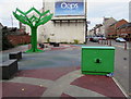
Green part of Commercial Road, Newport
A green Virgin Media telecoms cabinet and a green tree sculpture are on the west side of Commercial Road opposite Frederick Street. See http://www.geograph.org.uk/photo/5304215 for a closer view of the tree sculpture and some details.
Image: © Jaggery
Taken: 29 Oct 2017
0.03 miles
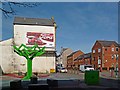
7
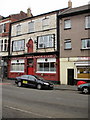
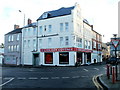
The Top of the Range Club, Newport
Located at 134 Commercial Road, near the corner of Temple Street.
Image: © Jaggery
Taken: 5 Oct 2009
0.03 miles
8
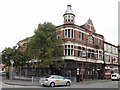
Former The Kings Arms, Commercial Road, Newport
Derelict former pub on the corner of Commercial Road and Temple Street.
Image: © Jaggery
Taken: 5 Oct 2009
0.03 miles
9
Corner of Albion Court and Capel Crescent, Newport
The northern edge of Albion Court, viewed across Capel Crescent.
Image: © Jaggery
Taken: 15 Dec 2010
0.03 miles
10
Chicken Cottage, Newport
Halal fast food takeaway, located on the corner of Commercial Road and Frederick Street.
Image: © Jaggery
Taken: 15 Dec 2010
0.03 miles