IMAGES TAKEN NEAR TO
Lower Dock Street, NEWPORT, NP20 2GD
Introduction
This page details the photographs taken nearby to Lower Dock Street, NP20 2GD by members of the Geograph project.
The Geograph project started in 2005 with the aim of publishing, organising and preserving representative images for every square kilometre of Great Britain, Ireland and the Isle of Man.

There are currently over 7.5m images from over14,400 individuals and you can help contribute to the project by visiting https://www.geograph.org.uk
Image Map
Images are licensed for reuse under creativecommons.org/licenses/by-sa/2.0
Notes
- Clicking on the map will re-center to the selected point.
- The higher the marker number, the further away the image location is from the centre of the postcode.
Image Listing (696 Images Found)
Images are licensed for reuse under creativecommons.org/licenses/by-sa/2.0
Image
Details
Distance
1
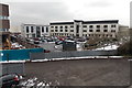
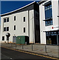
Usk House and Bradbury House, Newport
Viewed from George Street Bridge. The larger building dominating the view is Usk House located in Lower Dock Street. The smaller building on its left is Bradbury House, http://www.geograph.org.uk/photo/1599611 the Mission Court building housing the South and East Wales headquarters of the British Red Cross.
Image: © Jaggery
Taken: 22 Jan 2013
0.00 miles
2
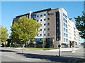
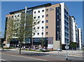
Opal 1, Endeavour House, Newport
Opal operates in 16 cities in the UK, with a total of 18,000 student rooms for rent. Their Newport building is located on the east side of Usk Way, adjacent to George Street Bridge and the River Usk.
The building is situated close to the new University of Wales Newport campus building. http://www.geograph.org.uk/photo/2068498
Image: © Jaggery
Taken: 4 Oct 2010
0.02 miles
3
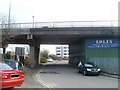
Road under George Street Bridge, Newport
Adjacent to Emlyn's premises, http://www.geograph.org.uk/photo/2307462 an unnamed road from Granville Square passes underneath the western end of George Street Bridge.
Image: © Jaggery
Taken: 14 Mar 2011
0.02 miles
4
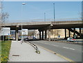
Newport : Usk Way passes under George Street Bridge
The western approach ramp to the central section of George Street Bridge http://www.geograph.org.uk/photo/1658628 passes above the A4042 (Usk Way).
Image: © Jaggery
Taken: 10 Apr 2011
0.02 miles
5
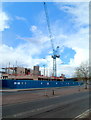
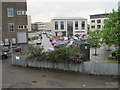
Magistrates' Court construction site, Newport
Viewed across Usk Way. The jib of a crane towers above the construction site,
where a magistrates' court is being erected. Work began here in the summer of
2011. The new building will contain four courtrooms and holding cells.
The existing magistrates' court in Clytha Park Road was declared
unfit for purpose more than a decade ago.
Image: © Jaggery
Taken: 11 Apr 2012
0.02 miles
6
Students and bunting outside Opal 1, Newport on Olympic Torch relay day
On Friday May 25th 2012, students wait outside Opal 1, Endeavour House, shortly before the passage of the Olympic Torch relay. The lower part of the building is decked with Union Jacks and bunting.
Viewed across Usk Way.
Image: © Jaggery
Taken: 25 May 2012
0.02 miles
7
Lower Dock Street electricity substation, Newport
Located near Red Cross regional headquarters http://www.geograph.org.uk/photo/1599611 set back from the east side of Lower Dock Street. The identifier on the dark green Western Power Distribution electricity substation is
LOWER DOCK STREET S/S 53-6973.
Image: © Jaggery
Taken: 21 Sep 2014
0.02 miles
8
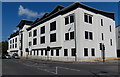
Usk House, Lower Dock Street, Newport
Viewed from the corner of John Street.
The office building extends for 65 metres along the east side of Lower Dock Street.
Its far end is near the George Street junction.
Image: © Jaggery
Taken: 21 Sep 2014
0.03 miles
9
Newport Dock Street railway station (site), Gwent
Opened in 1852 by the Monmouthshire Railway and Canal Company, later part of the Great Western Railway, as the terminus of its Western Valleys lines from Ebbw Vale and Blaina. It replaced an earlier station at Courtybella. This station closed to passengers in 1880 when services were transferred to the current High Street station, and completely in the 1960s.
View south from the B4237. As can be seen the area has been completely redeveloped but until the 1960s, this was a mass of railway lines and goods sheds.
Image: © Nigel Thompson
Taken: 14 Aug 2015
0.03 miles
10
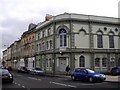
Masonic Hall, corner of Ruperra St & Lower Dock St, Newport
Image: © John Lord
Taken: 30 Mar 2011
0.03 miles