IMAGES TAKEN NEAR TO
Usk Way, NEWPORT, NP20 2FX
Introduction
This page details the photographs taken nearby to Usk Way, NP20 2FX by members of the Geograph project.
The Geograph project started in 2005 with the aim of publishing, organising and preserving representative images for every square kilometre of Great Britain, Ireland and the Isle of Man.

There are currently over 7.5m images from over14,400 individuals and you can help contribute to the project by visiting https://www.geograph.org.uk
Image Map
Images are licensed for reuse under creativecommons.org/licenses/by-sa/2.0
Notes
- Clicking on the map will re-center to the selected point.
- The higher the marker number, the further away the image location is from the centre of the postcode.
Image Listing (278 Images Found)
Images are licensed for reuse under creativecommons.org/licenses/by-sa/2.0
Image
Details
Distance
1
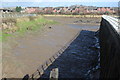
Riverside walkway, Jack's Pill, Newport
The riverside footpath along the west bank of the River Usk follows a course around a tidal inlet named Jack's Pill. http://www.geograph.org.uk/photo/2893885
Image: © Jaggery
Taken: 11 Apr 2012
0.02 miles
2
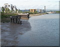
West bank of the River Usk, Newport
A view north from a viewing area, part of a long riverside path. The viewing area on the jetty in the middle distance is at the edge of Jack's Pill. http://www.geograph.org.uk/photo/2893885
Image: © Jaggery
Taken: 25 Apr 2011
0.02 miles
3
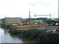
Redevelopment by the River Usk
Down river from George Street Bridge with Image in the distance.
Image: © Robin Drayton
Taken: 2 Aug 2008
0.02 miles
4

Llanarth Court, Newport
Block of flats on the edge of the Old Dock Area and next to the Riverside Walk, NCR 47.
Image: © M J Roscoe
Taken: 8 Feb 2020
0.04 miles
5

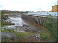
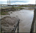
Jack's Pill
Jack's Pill is a 100-metre long tidal inlet on the west bank of the River Usk.
Image: © Eirian Evans
Taken: 23 Jul 2015
0.05 miles
6
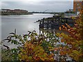
High tide on the River Usk
Looking down river towards the City Bridge http://www.geograph.org.uk/photo/1140452 .
Taken from Jack's Pill, a small inlet on the right.
In recent years land on both banks of the river has been redeveloped with housing and a walkway.
The remains of a wharf are a reminder of the river's past.
Image: © Robin Drayton
Taken: 7 Nov 2012
0.05 miles
7
Jack's Pill, Newport
A pill is a local word for a tidal inlet. Jack's Pill is a 100-metre long tidal inlet on the
west bank of the River Usk. At low tide, as now, the pill is an expanse of river mud.
In the distance are two of the towers of George Street bridge. http://www.geograph.org.uk/photo/1658628
Image: © Jaggery
Taken: 11 Apr 2012
0.05 miles
8
Jack's Pill, River Usk
A tidal inlet on the west bank of the river; The Riverside Walk, NCR 47 runs around the pill.
Image: © M J Roscoe
Taken: 8 Feb 2020
0.05 miles
9

Graffiti on hoardings by riverfront path, Newport
Image: © David Smith
Taken: 25 Sep 2021
0.05 miles
10

Modern office block and Jack's Pill, Newport
Pill means inlet or creek off a river or channel; in this case the River Usk.
Most of the original inlet is now lost under modern development.
For a view at low tide see http://www.geograph.org.uk/photo/2893885 .
Image: © Robin Drayton
Taken: 23 Jul 2012
0.06 miles