IMAGES TAKEN NEAR TO
Capel Crescent, NEWPORT, NP20 2FT
Introduction
This page details the photographs taken nearby to Capel Crescent, NP20 2FT by members of the Geograph project.
The Geograph project started in 2005 with the aim of publishing, organising and preserving representative images for every square kilometre of Great Britain, Ireland and the Isle of Man.

There are currently over 7.5m images from over14,400 individuals and you can help contribute to the project by visiting https://www.geograph.org.uk
Image Map
Images are licensed for reuse under creativecommons.org/licenses/by-sa/2.0
Notes
- Clicking on the map will re-center to the selected point.
- The higher the marker number, the further away the image location is from the centre of the postcode.
Image Listing (302 Images Found)
Images are licensed for reuse under creativecommons.org/licenses/by-sa/2.0
Image
Details
Distance
1
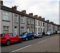
On-street parking, Capel Crescent, Newport
In the Pill area of Newport.
Image: © Jaggery
Taken: 29 Oct 2017
0.00 miles
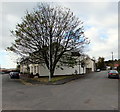
3
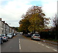
Autumn colours, Capel Crescent, Newport
Viewed on October 29th 2017.
Image: © Jaggery
Taken: 29 Oct 2017
0.03 miles
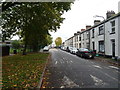
5
Tree at a V-junction, Pill, Newport
The V-shaped junction of Arthur Street (on the left) and Belle Vue Terrace in the Pill area of Newport.
Image: © Jaggery
Taken: 29 Oct 2017
0.04 miles
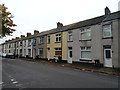
6
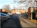
Capel Crescent flats, Newport
Flats on the NE side of Capel Crescent. The flats are numbered in the high 200s (eg 290 Capel Crescent). Unusually, the numbering sequence is used by housing built around the same time in neighbouring streets. For example, the twenty properties in nearby Kirby Lane are from 317 to 336, and the lowest number in Daniel Place is 384.
Image: © Jaggery
Taken: 15 Dec 2010
0.04 miles
7
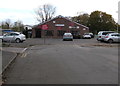
Pill Harriers Sports Club, Newport
Located at the NW edge of a recreation ground, the club building faces
the corner of Belle Vue Terrace and Arthur Street in the Pill area of Newport.
Image: © Jaggery
Taken: 29 Oct 2017
0.04 miles
8
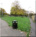
Bilingual text on a bin at the edge of a recreation ground, Pill, Newport
LITTER is on the left side, the Welsh SBWRIEL on the right side of the bin in the Pill area of Newport.
Image: © Jaggery
Taken: 29 Oct 2017
0.05 miles
9
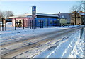
Pillgwenlly Flying Start, Newport
Recently-built creche and playgroup centre, located on the south side of Capel Crescent. Pillgwenlly is the official name for the area of Newport usually referred to as Pill.
Image: © Jaggery
Taken: 24 Dec 2010
0.05 miles
10
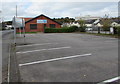
Bellevue Group Practice car park, Newport
The car park on the east side of Bellevue Group Practice http://www.geograph.org.uk/photo/5613575 is for practice visitors parking only.
Image: © Jaggery
Taken: 29 Oct 2017
0.06 miles