IMAGES TAKEN NEAR TO
Ariel Close, NEWPORT, NP20 2FN
Introduction
This page details the photographs taken nearby to Ariel Close, NP20 2FN by members of the Geograph project.
The Geograph project started in 2005 with the aim of publishing, organising and preserving representative images for every square kilometre of Great Britain, Ireland and the Isle of Man.

There are currently over 7.5m images from over14,400 individuals and you can help contribute to the project by visiting https://www.geograph.org.uk
Image Map
Images are licensed for reuse under creativecommons.org/licenses/by-sa/2.0
Notes
- Clicking on the map will re-center to the selected point.
- The higher the marker number, the further away the image location is from the centre of the postcode.
Image Listing (103 Images Found)
Images are licensed for reuse under creativecommons.org/licenses/by-sa/2.0
Image
Details
Distance
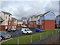
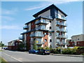
1
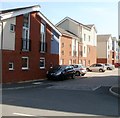
Ariel Close, Newport
Flats built c2009-2010, part of the Mariners Quay development.
Image: © Jaggery
Taken: 25 Apr 2011
0.01 miles
2
Ariel Reach, Newport
Flats at the SE edge of Mariners Quay, built c2009.
Image: © Jaggery
Taken: 25 Apr 2011
0.01 miles
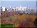
3
Alexandra Gate Housing, Newport
Situated on East Dock Road, Alexandra Gate is a 21st century housing development.
This is part of the regeneration of the Old Town Dock area of Newport.
Viewed across undeveloped land which has been screened with wild flowers.
The upper structure of the City Bridge http://www.geograph.org.uk/photo/1140452 can be seen in the background.
Image: © Robin Drayton
Taken: 15 Jun 2013
0.02 miles
4
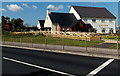
Blaina Wharf, Newport
Opened in 2014, Blaina Wharf is a Marston's Inns and Taverns new-build pub/restaurant.
This view towards the entrance is across the A48 Southern Distributor Road near the A4042 Usk Way junction, on the approach to Newport City Bridge over the River Usk. There is a children's menu and children's indoor and outdoor play areas.
Image: © Jaggery
Taken: 21 Sep 2014
0.04 miles
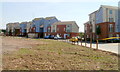
5
Alexandra Gate, Usk Way
Part of a new housing development of almost 400 units, close to the River Usk and the City Bridge.
Image: © Robin Drayton
Taken: 28 Jan 2009
0.05 miles
6
Riverside walk near City Bridge, Newport
Viewed from the western approach to City Bridge. http://www.geograph.org.uk/photo/2898305
The walk is along the west bank of the River Usk.
Image: © Jaggery
Taken: 25 Apr 2011
0.06 miles
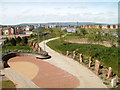
7
Riverside Park, Newport
This is the west bank of the River Usk as viewed from the City Bridge http://www.geograph.org.uk/photo/1140452 .
For another view and the history of this area see http://www.geograph.org.uk/photo/3359833 .
Image: © Robin Drayton
Taken: 5 Mar 2013
0.06 miles
8
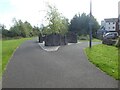
Planting with timber and trees, riverfront walk, Newport
Image: © David Smith
Taken: 25 Sep 2021
0.06 miles
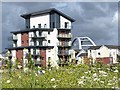
9
Penner Court, Ariel Close, Newport
Multi-storey block of flats built 2009. Part of the Mariners Quay development.
Image: © Jaggery
Taken: 25 Apr 2011
0.07 miles
10
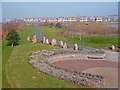
Riverside Park, Newport
At the end of the 20th century a large area of land on the west bank of the River Usk was mostly derelict. This was the site of a number of wharfs and the Old Town Dock.
Since then a large regeneration project has been put into action and much residential accommodation has been constructed. An area of land fronting the river was set aside as a riverside park with footpaths and cycleways.
This is the view from the City Bridge http://www.geograph.org.uk/photo/1140452 .
Image: © Robin Drayton
Taken: 5 Mar 2013
0.07 miles