IMAGES TAKEN NEAR TO
Capel Crescent, NEWPORT, NP20 2FG
Introduction
This page details the photographs taken nearby to Capel Crescent, NP20 2FG by members of the Geograph project.
The Geograph project started in 2005 with the aim of publishing, organising and preserving representative images for every square kilometre of Great Britain, Ireland and the Isle of Man.

There are currently over 7.5m images from over14,400 individuals and you can help contribute to the project by visiting https://www.geograph.org.uk
Image Map
Images are licensed for reuse under creativecommons.org/licenses/by-sa/2.0
Notes
- Clicking on the map will re-center to the selected point.
- The higher the marker number, the further away the image location is from the centre of the postcode.
Image Listing (258 Images Found)
Images are licensed for reuse under creativecommons.org/licenses/by-sa/2.0
Image
Details
Distance
1
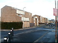
Raglan Court, Capel Crescent, Newport
Built in 1980, Raglan Court contains 58 rented flats and bungalows, designed for people aged at least 60. There is a non-resident management staff and community alarm service. This view is in the direction of Commercial Road.
Image: © Jaggery
Taken: 15 Dec 2010
0.03 miles
2
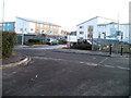
Capel Court and Capel Grange, Newport
Two adjacent modern buildings on the south side of Capel Crescent.
Capel Court, opened in February 2008, contains 40 flats. It was built by Linc-Cymru in partnership with Newport City Council. It is Newport’s third extraCare scheme, designed to accommodate older people in need of care.
Capel Grange is a 3-storey building. 12 of its 70 beds are dedicated EMI (elderly, mentally infirm) nursing beds. The other beds are for general nursing of the elderly in need of long-term medical care.
Image: © Jaggery
Taken: 15 Dec 2010
0.03 miles
3
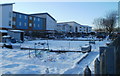
Capel Crescent allotments, Newport
Viewed from the NE corner of the allotments, which are located on the south side of Capel Crescent, one of 22 allotment sites owned by Newport City Council. Residents of the city may apply to the council to rent an allotment plot, to be used for growing vegetables, flowers, etc.
The blanket of snow helps reduce heat loss from the soil and maintains a higher temperature underneath than would be the case if the allotments were bare.
Image: © Jaggery
Taken: 24 Dec 2010
0.03 miles
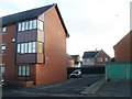
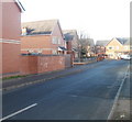
4
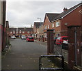
Albion Close, Newport
Modern housing viewed from the edge of Commercial Road in the Pill area of Newport.
Image: © Jaggery
Taken: 29 Oct 2017
0.04 miles
5
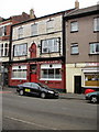
The Top of the Range Club, Newport
Located at 134 Commercial Road, near the corner of Temple Street.
Image: © Jaggery
Taken: 5 Oct 2009
0.04 miles
6
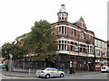
Former The Kings Arms, Commercial Road, Newport
Derelict former pub on the corner of Commercial Road and Temple Street.
Image: © Jaggery
Taken: 5 Oct 2009
0.04 miles
7
Corner of Albion Court and Capel Crescent, Newport
The northern edge of Albion Court, viewed across Capel Crescent.
Image: © Jaggery
Taken: 15 Dec 2010
0.04 miles
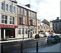
8
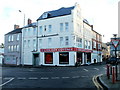
Chicken Cottage, Newport
Halal fast food takeaway, located on the corner of Commercial Road and Frederick Street.
Image: © Jaggery
Taken: 15 Dec 2010
0.04 miles
9
Albion Close, Newport
Modern housing viewed from the corner of Temple Street.
Image: © Jaggery
Taken: 15 Dec 2010
0.04 miles
10
Globe Taxis, Newport
Located at 83 Commercial Road, next door to Chicken Cottage. http://www.geograph.org.uk/photo/2199696
Image: © Jaggery
Taken: 24 Dec 2010
0.04 miles