IMAGES TAKEN NEAR TO
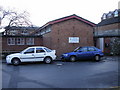
Mountjoy Road, NEWPORT, NP20 2FB
Introduction
This page details the photographs taken nearby to Mountjoy Road, NP20 2FB by members of the Geograph project.
The Geograph project started in 2005 with the aim of publishing, organising and preserving representative images for every square kilometre of Great Britain, Ireland and the Isle of Man.

There are currently over 7.5m images from over14,400 individuals and you can help contribute to the project by visiting https://www.geograph.org.uk
Image Map
Images are licensed for reuse under creativecommons.org/licenses/by-sa/2.0
Notes
- Clicking on the map will re-center to the selected point.
- The higher the marker number, the further away the image location is from the centre of the postcode.
Image Listing (782 Images Found)
Images are licensed for reuse under creativecommons.org/licenses/by-sa/2.0
Image
Details
Distance
1
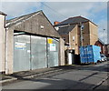
D.& J. Kerr, Newport
Vehicle repairs premises at 8 Mountjoy Street, near the Commercial Road junction.
The name sign shows Insurance Work, Welding/ MoTs.
Image: © Jaggery
Taken: 27 Jan 2013
0.03 miles
2
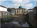
Mosque rear entrance from Mountjoy Road, Newport
The main entrance to Jamia Mosque is from Commercial Road. http://www.geograph.org.uk/photo/1789236
Image: © Jaggery
Taken: 27 Jan 2013
0.03 miles
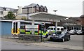
3
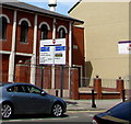
Commercial Road directions sign, Newport
Facing northbound traffic on the approach to the B4237 junction.
Image: © Jaggery
Taken: 24 Jun 2018
0.04 miles
4
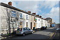
Mountjoy Street, Newport
Viewed from near the junction with Mountjoy Road and Mountjoy Place,
looking towards Commercial Road and an Asda superstore.
Image: © Jaggery
Taken: 27 Jan 2013
0.04 miles
5
Central Clinic, Tredegar Street, Newport
Located on the western edge of the former cattle market site, now an Asda superstore.
Image: © Jaggery
Taken: 27 Nov 2009
0.04 miles
6
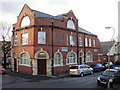
White Hart House, Newport
Located on West Market Street, adjacent to the former cattle market site now occupied by an Asda superstore. Formerly the White Hart pub, the current occupiers are Cambrian Fuelcard Services. The firm specialises in providing fuel cards that can be used at over 4500 sites in the UK, including major brand fuel stations and supermarket filling stations.
Image: © Jaggery
Taken: 27 Nov 2009
0.04 miles
8
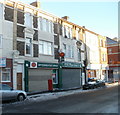
Commercial Road post office, Newport
Located at 32 Commercial Road, next door to Pill Pharmacy (not a would-be humorous name - Pill is the generally used shortened form of the official name of the area, Pillgwenlly).
The left turn ahead is into Albert Street.
Image: © Jaggery
Taken: 25 Dec 2010
0.04 miles
9
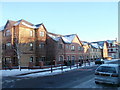
Drovers Mews, Newport
Viewed across Commercial Road. Drovers Mews contains 16 flats, located between Ruperra Street and Tredegar Street. The entrance and residents' parking area are in Tredegar Street.
Image: © Jaggery
Taken: 25 Dec 2010
0.04 miles
10
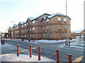
Windmill Square, Newport
Modern flats viewed across Commercial Road. Windmill Square is between Mountjoy Street and Alma Street.
Image: © Jaggery
Taken: 25 Dec 2010
0.04 miles