IMAGES TAKEN NEAR TO
King Street, NEWPORT, NP20 2EZ
Introduction
This page details the photographs taken nearby to King Street, NP20 2EZ by members of the Geograph project.
The Geograph project started in 2005 with the aim of publishing, organising and preserving representative images for every square kilometre of Great Britain, Ireland and the Isle of Man.

There are currently over 7.5m images from over14,400 individuals and you can help contribute to the project by visiting https://www.geograph.org.uk
Image Map
Images are licensed for reuse under creativecommons.org/licenses/by-sa/2.0
Notes
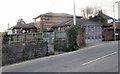
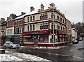
- Clicking on the map will re-center to the selected point.
- The higher the marker number, the further away the image location is from the centre of the postcode.
Image Listing (1160 Images Found)
Images are licensed for reuse under creativecommons.org/licenses/by-sa/2.0
Image
Details
Distance
1
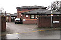
St Paul's Clinic, Newport
Located in Palmyra Place.
Image: © Jaggery
Taken: 14 Feb 2010
0.02 miles
2
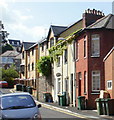
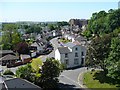
King Street, Newport
Houses on the north side of King Street viewed from the Cardiff Road end.
Image: © Jaggery
Taken: 20 Jun 2010
0.02 miles
3
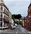
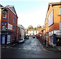
King Street, Newport
Dead end street extending for 70 metres from Cardiff Road.
Lilo Grill House http://www.geograph.org.uk/photo/5244414 is on the left.
Image: © Jaggery
Taken: 24 Jul 2016
0.02 miles
4
Queen Street, Newport
Viewed across Cardiff Road.
Image: © Jaggery
Taken: 24 Jul 2016
0.03 miles
5
Queen Street, Newport
Viewed across Cardiff Road looking towards the Royal British Legion club. http://www.geograph.org.uk/photo/1929556
Image: © Jaggery
Taken: 25 Dec 2013
0.03 miles
6
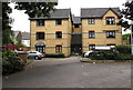
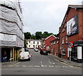
Wrenford Court, Newport
3-storey block of flats set back 65 metres from Commercial Street,
on the south side of the former St Paul's Church.
Image: © Jaggery
Taken: 24 Jul 2016
0.03 miles
7
Keynsham Avenue, Newport
The view in a southerly direction from the top of Park Square Multi-Storey Car Park with the Royal Gwent Hospital http://www.geograph.org.uk/photo/527560 at the upper right.
The green hill on the left in the distance is on the Newport City Waste Disposal Site and is man made http://www.geograph.org.uk/photo/471790 .
Image: © Robin Drayton
Taken: 1 Jun 2009
0.03 miles
8
St Paul's Clinic, Newport
In Palmyra Place, on the west side of St Paul's Church. http://www.geograph.org.uk/photo/1708420
Image: © Jaggery
Taken: 18 Dec 2014
0.04 miles
9
Former Lilo Grill House to let, Newport
Located on the corner of Cardiff Road and King Street. There is a To Let sign above the doorway near the zebra crossing. Lilo Grillhouse Inn Ltd, incorporated in January 2011, was dissolved on January 3rd 2013. The previous occupier was the Prince of Wales pub. http://www.geograph.org.uk/photo/1597334 Who will be the next occupier?
Image: © Jaggery
Taken: 22 Jan 2013
0.04 miles
10
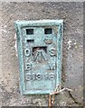
Ordnance Survey Flush Bracket (S1318)
This OS Flush Bracket can be found on the south angle of St Paul's Church. It marks a point 13.554m above mean sea level.
Image: © Adrian Dust
Taken: 17 Jun 2018
0.04 miles