IMAGES TAKEN NEAR TO
Daniel Place, NEWPORT, NP20 2EJ
Introduction
This page details the photographs taken nearby to Daniel Place, NP20 2EJ by members of the Geograph project.
The Geograph project started in 2005 with the aim of publishing, organising and preserving representative images for every square kilometre of Great Britain, Ireland and the Isle of Man.

There are currently over 7.5m images from over14,400 individuals and you can help contribute to the project by visiting https://www.geograph.org.uk
Image Map
Images are licensed for reuse under creativecommons.org/licenses/by-sa/2.0
Notes
- Clicking on the map will re-center to the selected point.
- The higher the marker number, the further away the image location is from the centre of the postcode.
Image Listing (574 Images Found)
Images are licensed for reuse under creativecommons.org/licenses/by-sa/2.0
Image
Details
Distance
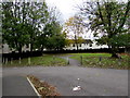
1
Corner of Herbert Walk and Alma Street, Newport
Viewed across Alma Street.
Image: © Jaggery
Taken: 17 Dec 2010
0.02 miles
2
Businesses on Cardiff Road, Newport
Funeral Directors (left) and health plan providers.
Image: © JThomas
Taken: 15 Oct 2019
0.04 miles
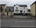
3

Tovey Bros, Cardiff Road, Newport
Daniel Tovey established the business in Dock Street, Newport in 1860. By the late 1880s, the firm was the leading coach builders and funeral furnishers in the area. By the early 1930s, motor vehicles replaced horse-drawn as the main mode of transport for funerals.
In the late 1950s, the council announced the Kingsway development which included the compulsory purchase and demolition of many Dock Street buildings, including the firm's premises. The firm bought the former private residence seen here, creating garages to replace stables at the rear of the building.
The building is a Grade II listed early to mid 19th century villa in the Greek Revival style.
Image: © Jaggery
Taken: 29 Oct 2017
0.04 miles
4
A view from the Royal Gwent Hospital, Newport (2)
Taken from level 4 of the hospital and showing the entrance from Cardiff Road. For the reverse view see https://www.geograph.org.uk/photo/5565199 .
Image: © Robin Drayton
Taken: 19 Aug 2018
0.04 miles
5
Herbert Street entrance to the Tovey Bros yard, Newport
The yard is on the northeast side of this building. http://www.geograph.org.uk/photo/5609569
Image: © Jaggery
Taken: 29 Oct 2017
0.04 miles
6
Concrete posts at the edge of Herbert Street, Newport
Preventing vehicular misuse of the footpath.
Image: © Jaggery
Taken: 29 Oct 2017
0.04 miles
7
Plutus Health, Newport
Health insurance agency at 13 Cardiff Road.
Image: © Jaggery
Taken: 24 Jul 2016
0.04 miles
8
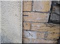
Ordnance Survey Cut Mark
This OS cut mark can be found on No17 Cardiff Road. It marks a point 11.297m above mean sea level.
Image: © Adrian Dust
Taken: 17 Jun 2018
0.04 miles
9
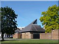
Emmanuel Evangelical Church, Newport
The Church was established in 1866 following a visit of Charles Spurgeon to Newport. A chapel was erected in Alma Street and opened in 1875, serving the congregation until 1976 when the building was demolished due to the redevelopment of the Pillgwenlly area of Newport. This building was constructed in 1977 and the name was changed from Alma Street Baptist Church to Emmanuel Evangelical Church.
Image: © Robin Drayton
Taken: 9 Aug 2007
0.05 miles
10
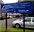
Emmanuel Evangelical Church (Baptist) direction sign, Cardiff Road, Newport
The white arrow points right towards the church entrance in Rutland Place. http://www.geograph.org.uk/photo/5609527
Image: © Jaggery
Taken: 29 Oct 2017
0.05 miles