IMAGES TAKEN NEAR TO
Clytha Square, NEWPORT, NP20 2EF
Introduction
This page details the photographs taken nearby to Clytha Square, NP20 2EF by members of the Geograph project.
The Geograph project started in 2005 with the aim of publishing, organising and preserving representative images for every square kilometre of Great Britain, Ireland and the Isle of Man.

There are currently over 7.5m images from over14,400 individuals and you can help contribute to the project by visiting https://www.geograph.org.uk
Image Map
Images are licensed for reuse under creativecommons.org/licenses/by-sa/2.0
Notes
- Clicking on the map will re-center to the selected point.
- The higher the marker number, the further away the image location is from the centre of the postcode.
Image Listing (779 Images Found)
Images are licensed for reuse under creativecommons.org/licenses/by-sa/2.0
Image
Details
Distance

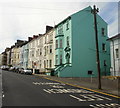
2
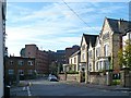
Top of Clytha Square
With a side entrance to the Royal Gwent Hospital.
Image: © Robin Drayton
Taken: 16 Oct 2008
0.01 miles
3
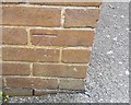
Ordnance Survey Cut Mark
This OS cut mark can be found on the Hospital Offices SW side of Clytha Square. It marks a point 20.896m above mean sea level.
Image: © Adrian Dust
Taken: 17 Jun 2018
0.01 miles
4
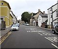
Clytha Square, Newport
The road ascends from Cardiff Road towards Dewsland Park Road.
Image: © Jaggery
Taken: 24 Jul 2016
0.02 miles
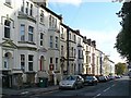
5
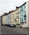
Row of three-storey houses, Clytha Square, Newport
Viewed from the corner of Cardiff Road. The 19th century houses date from an era when many Victorian middle-class families had domestic servants. Here, the servants' rooms were on the top floor in smaller accommodation than on the two lower floors.
Image: © Jaggery
Taken: 24 Jul 2016
0.02 miles
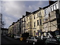
8
Clytha Square north side, Newport
Clytha Square is part of a planned development dating from the third quarter of the nineteenth century. The continuous terrace development of three storeys, framing the northern (seen here) and southern http://www.geograph.org.uk/photo/1887020 sides of Clytha Square, was constructed between 1870 and 1880.
Image: © Jaggery
Taken: 30 May 2010
0.04 miles
9
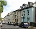
Clytha Square south side, Newport
Clytha Square is part of a planned development dating from the third quarter of the nineteenth century. The continuous terrace development of three storeys, on the southern (seen here) and northern http://www.geograph.org.uk/photo/1887010 sides of Clytha Square, was constructed between 1870 and 1880.
Image: © Jaggery
Taken: 30 May 2010
0.04 miles
10
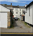
Grove Lane, Newport
A short cobbled lane connecting the northern http://www.geograph.org.uk/photo/1887010 and southern http://www.geograph.org.uk/photo/1887020 sides of Clytha Square.
Image: © Jaggery
Taken: 30 May 2010
0.04 miles