IMAGES TAKEN NEAR TO
Frederick Street, NEWPORT, NP20 2DR
Introduction
This page details the photographs taken nearby to Frederick Street, NP20 2DR by members of the Geograph project.
The Geograph project started in 2005 with the aim of publishing, organising and preserving representative images for every square kilometre of Great Britain, Ireland and the Isle of Man.

There are currently over 7.5m images from over14,400 individuals and you can help contribute to the project by visiting https://www.geograph.org.uk
Image Map
Images are licensed for reuse under creativecommons.org/licenses/by-sa/2.0
Notes
- Clicking on the map will re-center to the selected point.
- The higher the marker number, the further away the image location is from the centre of the postcode.
Image Listing (287 Images Found)
Images are licensed for reuse under creativecommons.org/licenses/by-sa/2.0
Image
Details
Distance
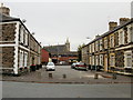
1
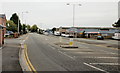
Frederick Street, Newport
Frederick Street heads away from Commercial Road towards Usk Way (A4042). On the near left is the turning for Frederick Mews.
Formerly a cul-de-sac, Frederick Street was widened following house demolition, and extended to connect with the then newly-built Usk Way. The houses were replaced by business premises.
Image: © Jaggery
Taken: 5 Oct 2009
0.01 miles
2
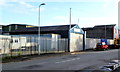
Broad Street Garage, Newport
Located near the Frederick Street end of Broad Street. The garage specialises in car and light commercial vehicle repairs.
The red and blue Springvale Weatherproofing premises http://www.geograph.org.uk/photo/2720993 are at the right edge of the view.
Image: © Jaggery
Taken: 3 Dec 2011
0.01 miles
3
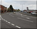
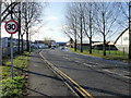
Frederick Street, Newport
Formerly much narrower, Frederick Street extends from Commercial Road to Usk Way.
The left turn behind the 30mph sign is into Frederick Mews.
Image: © Jaggery
Taken: 29 Oct 2017
0.04 miles
4
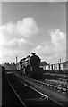
Scrap locomotives at Pill, Newport ? 1963
Former GWR King class locomotives waiting to be moved into the main Cashmore's scrapyard, stored alongside Frederick Street. The houses have disappeared and the area is now a light industrial estate.
Image: © Alan Murray-Rust
Taken: 9 Mar 1963
0.04 miles
5
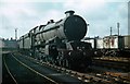
Scrap locomotives at Pill, Newport ? 1963
Former GWR King class locomotives waiting to be moved into the main Cashmore's scrapyard, stored alongside Frederick Street. The houses have disappeared and the area is now a light industrial estate.
Image: © Alan Murray-Rust
Taken: 9 Mar 1963
0.04 miles
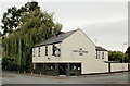
6
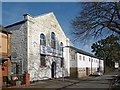
The Colour Centre, Portland Street, Newport
Trade and retail supplier of paint and other decorating equipment.
Formerly Portland Street Methodist Chapel.
The entry on the National Monuments Record of Wales website (Coflein) states “Portland Street Methodist Chapel was built during the late nineteenth century in the Simple Round-Headed style of the gable-entry type. By 1996 this chapel had been converted for use as a paint shop".
Image: © Robin Drayton
Taken: 2 Mar 2017
0.04 miles
7
Frederick Street, Newport
Frederick Street heads away from Usk Way towards Commercial Road.
Image: © Jaggery
Taken: 30 Nov 2009
0.05 miles
8
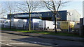
Commercial Motors Ltd, Newport
Van centre on Frederick Street.
Image: © Jaggery
Taken: 30 Nov 2009
0.05 miles
9
Trinity Place, Newport
Viewed from the corner of Portland Street, looking towards Potter Street.
In the distance is St Michaels RC Church. http://www.geograph.org.uk/photo/1600989
Image: © Jaggery
Taken: 5 Oct 2009
0.07 miles
10
The Church House Inn, Portland Street, Newport
Located on the corner of Portland Street and Broad Street.
A blue plaque http://www.geograph.org.uk/photo/1792624 on the wall records that William Henry Davies (1871-1940), poet and author, was born here. W.H. Davies, one of the most popular poets of his time, spent a large part of his adult life as a tramp or hobo in the United States and United Kingdom.
He is probably best known for the opening two lines of the poem Leisure, first published in 1911:
What is this life if, full of care,
We have no time to stand and stare.
Image: © Jaggery
Taken: 5 Oct 2009
0.07 miles