IMAGES TAKEN NEAR TO
Kings Parade, NEWPORT, NP20 2DN
Introduction
This page details the photographs taken nearby to Kings Parade, NP20 2DN by members of the Geograph project.
The Geograph project started in 2005 with the aim of publishing, organising and preserving representative images for every square kilometre of Great Britain, Ireland and the Isle of Man.

There are currently over 7.5m images from over14,400 individuals and you can help contribute to the project by visiting https://www.geograph.org.uk
Image Map
Images are licensed for reuse under creativecommons.org/licenses/by-sa/2.0
Notes
- Clicking on the map will re-center to the selected point.
- The higher the marker number, the further away the image location is from the centre of the postcode.
Image Listing (177 Images Found)
Images are licensed for reuse under creativecommons.org/licenses/by-sa/2.0
Image
Details
Distance
1
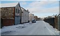
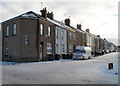
King's Parade, Newport
Looking towards Portland Street along King's Parade from the corner of Wilson Street. http://www.geograph.org.uk/photo/2207395
Image: © Jaggery
Taken: 24 Dec 2010
0.01 miles
2
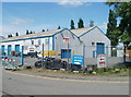
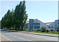
Tiles 4 Less, Newport
Trade warehouse on the west side of Usk Way, near the A48 junction.
Image: © Jaggery
Taken: 25 Apr 2011
0.06 miles
3
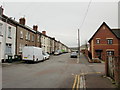
Castle Street, Newport
Victorian terraced housing on one side of the street contrasts with modern housing on the other side. Viewed from the corner of Portland Street. On the right is the turning for Potter Street.
Image: © Jaggery
Taken: 5 Oct 2009
0.06 miles
4
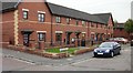
South side of Potter Street, Newport
Modern housing on the south side of Potter Street contrasts with Victorian terraced houses on the other side of the street. http://www.geograph.org.uk/photo/1792684
Image: © Jaggery
Taken: 5 Oct 2009
0.06 miles
5
Castle Street, Newport
Viewed from the corner of Portland Street. The houses, dating from about 1900, are on the east side of Castle Street. There is some modern housing on the other side of the street. http://www.geograph.org.uk/photo/1792640
Image: © Jaggery
Taken: 24 Dec 2010
0.06 miles
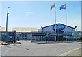
6
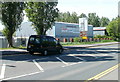
Newport Caravans, Usk Way
Caravan dealers' premises viewed across Usk Way (A4042).
Image: © Jaggery
Taken: 25 Apr 2011
0.07 miles
7
Day's Rental, Usk Way, Newport
A sign on the premises shows that cars, vans, trucks and minibuses are available for hire.
Image: © Jaggery
Taken: 25 Apr 2011
0.07 miles
8
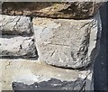
Ordnance Survey Cut Mark
This OS cut mark can be found on the south angle of St Michael's Church. It marks a point 10.388m above mean sea level.
Image: © Adrian Dust
Taken: 9 Jun 2018
0.08 miles
9
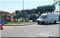
Oil storage tanks, Baltic Oil Works, Newport
Part of the premises of Stephens Fuel Oil. A Grade II listed building http://www.geograph.org.uk/photo/2898109 is nearby
Image: © Jaggery
Taken: 25 Apr 2011
0.08 miles
10
Entrance to Newport Auctions site
Located on the west side of Usk Way adjacent to Baltic Oil Works, (the Stephens Fuel Oil premises).
Image: © Jaggery
Taken: 25 Apr 2011
0.08 miles