1
King's Parade, Newport
Looking towards Portland Street along King's Parade from the corner of Wilson Street. http://www.geograph.org.uk/photo/2207395
Image: © Jaggery
Taken: 24 Dec 2010
0.03 miles
2
Castle Street, Newport
Victorian terraced housing on one side of the street contrasts with modern housing on the other side. Viewed from the corner of Portland Street. On the right is the turning for Potter Street.
Image: © Jaggery
Taken: 5 Oct 2009
0.03 miles
3
South side of Potter Street, Newport
Modern housing on the south side of Potter Street contrasts with Victorian terraced houses on the other side of the street. http://www.geograph.org.uk/photo/1792684
Image: © Jaggery
Taken: 5 Oct 2009
0.03 miles
4
Castle Street, Newport
Viewed from the corner of Portland Street. The houses, dating from about 1900, are on the east side of Castle Street. There is some modern housing on the other side of the street. http://www.geograph.org.uk/photo/1792640
Image: © Jaggery
Taken: 24 Dec 2010
0.03 miles
5
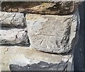
Ordnance Survey Cut Mark
This OS cut mark can be found on the south angle of St Michael's Church. It marks a point 10.388m above mean sea level.
Image: © Adrian Dust
Taken: 9 Jun 2018
0.06 miles
6
St Michaels RC Church, Newport
Located on the corner of St Michael Street and Clarence Street. Late Victorian Roman Catholic church : the foundation stone was laid in August 1886.
Image: © Jaggery
Taken: 30 Nov 2009
0.07 miles
7
Linton Street, Newport
Houses on the south side of the street, viewed from the corner of King's Parade, looking towards Castle Street. The north side of the street is occupied by the edges of houses in King's Parade and Castle Street.
Image: © Jaggery
Taken: 24 Dec 2010
0.07 miles
8
Wallis Street, Newport
Viewed from the corner of King's Parade. In the distance is St Michaels RC Church.http://www.geograph.org.uk/photo/1600989
Image: © Jaggery
Taken: 24 Dec 2010
0.07 miles
9
Newport Caravans, Usk Way
Caravan dealers' premises viewed across Usk Way (A4042).
Image: © Jaggery
Taken: 25 Apr 2011
0.07 miles
10
Day's Rental, Usk Way, Newport
A sign on the premises shows that cars, vans, trucks and minibuses are available for hire.
Image: © Jaggery
Taken: 25 Apr 2011
0.07 miles


