IMAGES TAKEN NEAR TO
Drovers Mews, Tredegar Street, NEWPORT, NP20 2BJ
Introduction
This page details the photographs taken nearby to Drovers Mews, Tredegar Street, NP20 2BJ by members of the Geograph project.
The Geograph project started in 2005 with the aim of publishing, organising and preserving representative images for every square kilometre of Great Britain, Ireland and the Isle of Man.

There are currently over 7.5m images from over14,400 individuals and you can help contribute to the project by visiting https://www.geograph.org.uk
Image Map
Images are licensed for reuse under creativecommons.org/licenses/by-sa/2.0
Notes
- Clicking on the map will re-center to the selected point.
- The higher the marker number, the further away the image location is from the centre of the postcode.
Image Listing (846 Images Found)
Images are licensed for reuse under creativecommons.org/licenses/by-sa/2.0
Image
Details
Distance
1
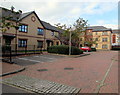
Drovers Mews, Newport
Flats viewed from Tredegar Street.
Image: © Jaggery
Taken: 29 Oct 2017
0.01 miles
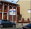
2
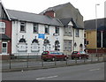
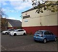
St. Joseph's Amateur Boxing Club, Newport
Situated on George Street, near the junction with Commercial Road.
UPDATE This http://www.geograph.org.uk/photo/3307544 January 2013 view shows different displays in the windows.
Image: © Jaggery
Taken: 13 Aug 2009
0.02 miles
3
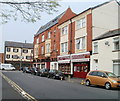
House Clearance Wales, Ruperra Street, Newport
Business premises near the Commercial Road end of Ruperra Street. In the distance is the Irish Club. http://www.geograph.org.uk/photo/2209837
Image: © Jaggery
Taken: 18 Apr 2011
0.02 miles
4
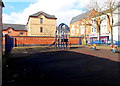
Children's play area, Ruperra Street and West Market Street, Newport
Viewed from the West Market Street side.
Image: © Jaggery
Taken: 16 Mar 2013
0.02 miles
5
Commercial Road directions sign, Newport
Facing northbound traffic on the approach to the B4237 junction.
Image: © Jaggery
Taken: 24 Jun 2018
0.02 miles
6
Junction of Tredegar Street and Drovers Mews, Newport
The left turn is into Drovers Mews. http://www.geograph.org.uk/photo/5610055
Image: © Jaggery
Taken: 29 Oct 2017
0.02 miles
7
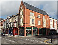
A.B.Florist, Newport
Florists on the corner of Commercial Road and Ruperra Street.
Image: © Jaggery
Taken: 27 Jan 2013
0.02 miles
8
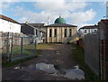
Mosque rear entrance from Mountjoy Road, Newport
The main entrance to Jamia Mosque is from Commercial Road. http://www.geograph.org.uk/photo/1789236
Image: © Jaggery
Taken: 27 Jan 2013
0.02 miles
9
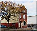
Relic of the former White Hart pub, Pill, Newport
In October 2017, the White Hart name and an Ushers of Trowbridge sign remain on White Hart House, currently the premises of Cambrian Fuelcard Services whose nameboard is also on the wall. This photo http://www.geograph.org.uk/photo/588909 taken in 1975 shows the White Hart pub.
Image: © Jaggery
Taken: 29 Oct 2017
0.03 miles
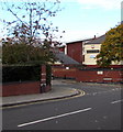
10
BT phonebox and a tree at the edge of White Hart House, Newport
On the Tredegar Street side of White Hart House, formerly the White Hart pub, seen here http://www.geograph.org.uk/photo/588909 in 1975.
Image: © Jaggery
Taken: 29 Oct 2017
0.03 miles