IMAGES TAKEN NEAR TO
Ruperra Street, NEWPORT, NP20 2BA
Introduction
This page details the photographs taken nearby to Ruperra Street, NP20 2BA by members of the Geograph project.
The Geograph project started in 2005 with the aim of publishing, organising and preserving representative images for every square kilometre of Great Britain, Ireland and the Isle of Man.

There are currently over 7.5m images from over14,400 individuals and you can help contribute to the project by visiting https://www.geograph.org.uk
Image Map
Images are licensed for reuse under creativecommons.org/licenses/by-sa/2.0
Notes
- Clicking on the map will re-center to the selected point.
- The higher the marker number, the further away the image location is from the centre of the postcode.
Image Listing (897 Images Found)
Images are licensed for reuse under creativecommons.org/licenses/by-sa/2.0
Image
Details
Distance
1
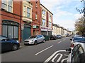
East along Ruperra Street, Newport
From the corner of Commercial Road in the Pill area of Newport.
Image: © Jaggery
Taken: 29 Oct 2017
0.01 miles
2
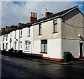
Four tall chimney pots, Ruperra Street, Newport
Viewed from the corner of Ruperra Street and New Ruperra Street.
This is the only surviving set of tall chimney pots in this part of the street. Several houses behind the camera have similar chimney pots, http://www.geograph.org.uk/photo/2335016 so perhaps they were an original feature of these Victorian houses.
Image: © Jaggery
Taken: 16 Mar 2013
0.01 miles
3
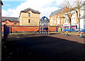
Children's play area, Ruperra Street and West Market Street, Newport
Viewed from the West Market Street side.
Image: © Jaggery
Taken: 16 Mar 2013
0.02 miles
4
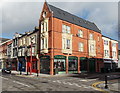
A.B.Florist, Newport
Florists on the corner of Commercial Road and Ruperra Street.
Image: © Jaggery
Taken: 27 Jan 2013
0.02 miles
5
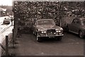
1972 Rolls Royce Silver Shadow
In a car park off West Market Street, Newport
Image: © Geographer
Taken: Unknown
0.03 miles
6
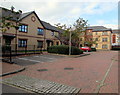
Drovers Mews, Newport
Flats viewed from Tredegar Street.
Image: © Jaggery
Taken: 29 Oct 2017
0.03 miles
7
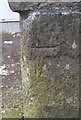
Ordnance Survey Cut Mark
This damaged OS cut mark can be found on the gatepost south side of Ruperra Street. It marks a point 9.144m above mean sea level.
Image: © Adrian Dust
Taken: 17 Jun 2018
0.04 miles
8
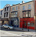
A red shop and a blue shop to let, Commercial Road, Newport
These empty shops were recently renovated as part of the Pillgwenlly Regeneration Project, a 4-year programme for major regeneration in the Pillgwenlly area through environmental improvements, a business grants scheme, and the creation of a community resource centre. The project has been backed by a £6.7m funding package, including support from Newport City Council, the European Regional Development Fund, Targeted Match Fund and Newport Unlimited.
Pillgwenlly is the official name for the area of Newport known in everyday speech as Pill.
Image: © Jaggery
Taken: 27 Jan 2013
0.04 miles
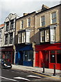
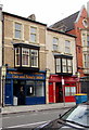
9
Masala 2 in 1 Grill opening soon, Newport
Viewed across Commercial Road near the corner of Ruperra Street in July 2014.
A notice showing OPENING SOON is in a window on the right. The Picton Arms pub is on the left.
Image: © Jaggery
Taken: 20 Jul 2014
0.04 miles
10
Fabulous Hair and Beauty Salon, Newport
Viewed across Commercial Road.
Image: © Jaggery
Taken: 29 Oct 2017
0.04 miles