IMAGES TAKEN NEAR TO
Ruperra Street, NEWPORT, NP20 2AZ
Introduction
This page details the photographs taken nearby to Ruperra Street, NP20 2AZ by members of the Geograph project.
The Geograph project started in 2005 with the aim of publishing, organising and preserving representative images for every square kilometre of Great Britain, Ireland and the Isle of Man.

There are currently over 7.5m images from over14,400 individuals and you can help contribute to the project by visiting https://www.geograph.org.uk
Image Map
Images are licensed for reuse under creativecommons.org/licenses/by-sa/2.0
Notes
- Clicking on the map will re-center to the selected point.
- The higher the marker number, the further away the image location is from the centre of the postcode.
Image Listing (871 Images Found)
Images are licensed for reuse under creativecommons.org/licenses/by-sa/2.0
Image
Details
Distance
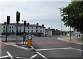
2
Blocked-off eastern end of Ruperra Street, Newport
Viewed from Lower Dock Street. Newport Masonic Hall http://www.geograph.org.uk/photo/1599573 is on the left.
Image: © Jaggery
Taken: 21 Sep 2014
0.02 miles
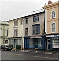
3
Empty former Waterbed Centre, Newport
The name remains on the empty Lower Dock Street shop. Notices in the window show "RELOCATING" but no new address is shown, only a phone number for sales and servicing.
Image: © Jaggery
Taken: 22 Jan 2013
0.02 miles
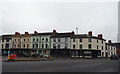
4
Emlyn and Attwoolls, Granville Square, Newport
Two business premises alongside the west side of the George Street Bridge.
Emlyn's sign shows "Tarpaulin Manufacturers and Canvas Goods".
Attwolls (Wales) sign shows "Marquee and Tent Contractors".
The building in the background is Opal 1, Endeavour House. http://www.geograph.org.uk/photo/2097229
Image: © Jaggery
Taken: 14 Mar 2011
0.02 miles
5
Dragon's Bite Deli, Newport
Baguette bar in Lower Dock Street, next to the empty former Waterbed Centre. http://www.geograph.org.uk/photo/3307493
Image: © Jaggery
Taken: 22 Jan 2013
0.03 miles
6
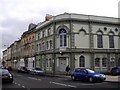
110 Lower Dock Street, Newport
Located opposite Newport Masonic Hall http://www.geograph.org.uk/photo/1599573 this building on the corner of Ruperra Street looks like it used to be a pub. It was. Kelly's Directory of Monmouthshire (1901 edition) shows that it was the Masonic public house, proprietor Mrs Annie Jones. Its address at that time was 110 Dock Street.
The addition of Lower followed the building of the Kingsway Centre in the 1970s which severed Dock Street into two disconnected parts.
Image: © Jaggery
Taken: 21 Sep 2014
0.03 miles
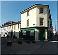
8
The Vulcan, Newport
At the junction of George Street and Lower Dock Street.
Image: © Eirian Evans
Taken: 25 Jun 2015
0.03 miles
9
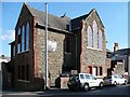
Barnabas Arts House, New Ruperra Street
This building was originally a church, the foundation stone being laid on 10th May 1906 by Viscount Tredegar.
It has for some years been used as a printing works but became an arts venue in 2009 and now contains artists' studios, exhibition space and performance areas.
Image: © Robin Drayton
Taken: 13 Oct 2009
0.03 miles
10
Masonic Hall, corner of Ruperra St & Lower Dock St, Newport
Image: © John Lord
Taken: 30 Mar 2011
0.04 miles