IMAGES TAKEN NEAR TO
High Street, NEWPORT, NP20 1YN
Introduction
This page details the photographs taken nearby to High Street, NP20 1YN by members of the Geograph project.
The Geograph project started in 2005 with the aim of publishing, organising and preserving representative images for every square kilometre of Great Britain, Ireland and the Isle of Man.

There are currently over 7.5m images from over14,400 individuals and you can help contribute to the project by visiting https://www.geograph.org.uk
Image Map
Images are licensed for reuse under creativecommons.org/licenses/by-sa/2.0
Notes
- Clicking on the map will re-center to the selected point.
- The higher the marker number, the further away the image location is from the centre of the postcode.
Image Listing (3225 Images Found)
Images are licensed for reuse under creativecommons.org/licenses/by-sa/2.0
Image
Details
Distance
1
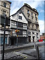
Olde Muringer House, Newport
The lower part of this building existed in 1533, and could have been built many years earlier. In the 16th century it was one of the homes of the High Sheriff of Monmouthshire. The sheriffs belonged to the influential Herbert family, descendants of the first Earl of Pembroke.
The building became a pub, called the Fleur-de-Lys, in the 17th century. It is now a Sam Smith pub.
Image: © Eirian Evans
Taken: 2 Aug 2014
0.00 miles
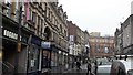
2
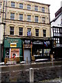
High Street Chambers, Newport
Viewed on March 4th 2018. A Roberts Commercial board on High Street Chambers states that 1st & 2nd offices have the potential to be converted to residential flats. Slipping Jimmy's Bar & Grill is on the right.
Image: © Jaggery
Taken: 4 Mar 2018
0.01 miles
3
High Street side of the Greyhound pub, Newport
Viewed from the corner of Market Street in April 2021.
The Greyhound also has an entrance from Cambrian Road. https://www.geograph.org.uk/photo/6235516
The Courtyard on the right also has a Cambrian Road entrance.
Image: © Jaggery
Taken: 17 Apr 2021
0.01 miles
4

Vivid blue wheelie bins, High Street, Newport
Three large Smiths Waste Management wheelie bins outside The Courtyard in February 2022.
Image: © Jaggery
Taken: 22 Feb 2022
0.01 miles
5
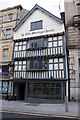
Ye Olde Murenger House
Ye Olde Murenger House public house dates from the early sixteenth century and stands on the High Street in Newport.
Image: © Philip Halling
Taken: 11 May 2013
0.01 miles
6
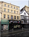
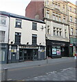
Slipping Jimmy's Bar & Grill, Newport
Steak house, bar and grill at 51-52 High Street.
Grade II listed Ye Olde Murenger House http://www.geograph.org.uk/photo/2792753 is on the right.
Image: © Jaggery
Taken: 9 Apr 2016
0.01 miles
7
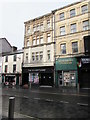
High Street Chambers, Newport
At 51 High Street. The Courtyard and the Greyhound are on the left.
An edge of Slipping Jimmy's Bar & Grill http://www.geograph.org.uk/photo/4900257 is on the right.
Image: © Jaggery
Taken: 9 Apr 2016
0.01 miles
8
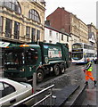
Vehicles in High Street, Newport
A Newport City Council Dennis refuse collection lorry and a NAT (New Adventure Travel) double-decker bus.
Image: © Jaggery
Taken: 27 May 2016
0.01 miles
9
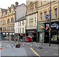
High Street gulls, Newport
Waste sacks have been pierced and part of their contents strewn across High Street in the search for food.
Image: © Jaggery
Taken: 6 Jun 2016
0.01 miles
10
High Street, Newport
The 16th century Murenger House survives to distinguish the High Street with its jetties and white gable end.
Image: © Chris Brown
Taken: 6 Dec 2016
0.01 miles