IMAGES TAKEN NEAR TO
Stow Hill, NEWPORT, NP20 1TP
Introduction
This page details the photographs taken nearby to Stow Hill, NP20 1TP by members of the Geograph project.
The Geograph project started in 2005 with the aim of publishing, organising and preserving representative images for every square kilometre of Great Britain, Ireland and the Isle of Man.

There are currently over 7.5m images from over14,400 individuals and you can help contribute to the project by visiting https://www.geograph.org.uk
Image Map
Images are licensed for reuse under creativecommons.org/licenses/by-sa/2.0
Notes
- Clicking on the map will re-center to the selected point.
- The higher the marker number, the further away the image location is from the centre of the postcode.
Image Listing (3409 Images Found)
Images are licensed for reuse under creativecommons.org/licenses/by-sa/2.0
Image
Details
Distance
1

Jubilee Year of Mercy 2015-2016 banner in Newport city centre
Showing a quote from Pope Francis (the 266th and current Pope of the Roman Catholic Church),
the banner is on a School Lane wall http://www.geograph.org.uk/photo/5071137 near St Mary's Catholic Church. Viewed in mid August 2016.
Image: © Jaggery
Taken: 12 Aug 2016
0.01 miles
2
Banner on a School Lane wall, Newport
See http://www.geograph.org.uk/photo/5071132 for a closer view of the banner.
Image: © Jaggery
Taken: 12 Aug 2016
0.01 miles
3
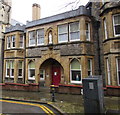
St Mary's Presbytery and Parish Office, Stow Hill, Newport
On March 19th 2020 a notice https://www.geograph.org.uk/photo/6418298 on the red door states "We regret to inform you that due to the current situation with the Coronavirus, the parish office will be closed until further notice".
Image: © Jaggery
Taken: 19 Mar 2020
0.02 miles
4
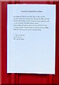
Coronavirus precautions notice, Stow Hill, Newport
On the red door here https://www.geograph.org.uk/photo/6418296 on March 19th 2020.
Image: © Jaggery
Taken: 19 Mar 2020
0.02 miles
5

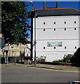
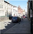
Stow Hill Pedestrianised Zone, Newport
Despite signs showing No Vehicles 11am - 5pm this isn't a traffic-free pedestrianised zone.
Cars are parked on the right and the route ahead is used by many buses an hour at peak times.
Image: © Jaggery
Taken: 21 Nov 2015
0.02 miles
6
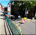
Temporary closure of the northern end of Stow Hill, Newport
Stow Hill north of the School Lane junction is closed to traffic on May 14th 2018.
Buses which normally use this route to Market Square bus station or Friars Walk
bus station are being diverted via North Street in the Baneswell area of Newport.
Image: © Jaggery
Taken: 14 May 2018
0.02 miles
7
No cycling sign, Stow Hill, Newport
On lamppost NL207 outside St Mary's Roman Catholic Church.
Some pavements in the city are combined footpaths and cycleways. This one isn't.
Image: © Jaggery
Taken: 12 Aug 2016
0.02 miles
8
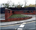
Territorial Army Memorial, Stow Hill, Newport
Located on the corner of Stow Hill and School Lane.
The blackened wall in the background was part of the demolished Stow Hill Drill Hill.
Memorial plaques http://www.geograph.org.uk/photo/3216943 record the heroic stand of the Monmouthshire Regiment at Ypres in 1915.
Image: © Jaggery
Taken: 8 Nov 2012
0.02 miles
9
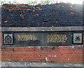
Memorial plaques, Stow Hill, Newport
Located on the corner of Stow Hill and School Lane http://www.geograph.org.uk/photo/3216933 at the edge of a demolished drill hall.
The plaque on the right records the saddest yet most glorious chapter in Newport's history on May 8th 1915 when in an heroic stand against great odds before Ypres, the Monmouthshires helped to bar the Germans from the vital Channel ports. Of their strength of nearly 500, only 129 officers and men survived.
Image: © Jaggery
Taken: 8 Nov 2012
0.02 miles
10
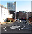
Mini-roundabout in Newport city centre
At the junction of Stow Hill and School Lane, viewed from the Stow Hill elevated pavement.
Image: © Jaggery
Taken: 21 Nov 2015
0.02 miles