IMAGES TAKEN NEAR TO
North Street, NEWPORT, NP20 1TE
Introduction
This page details the photographs taken nearby to North Street, NP20 1TE by members of the Geograph project.
The Geograph project started in 2005 with the aim of publishing, organising and preserving representative images for every square kilometre of Great Britain, Ireland and the Isle of Man.

There are currently over 7.5m images from over14,400 individuals and you can help contribute to the project by visiting https://www.geograph.org.uk
Image Map
Images are licensed for reuse under creativecommons.org/licenses/by-sa/2.0
Notes
- Clicking on the map will re-center to the selected point.
- The higher the marker number, the further away the image location is from the centre of the postcode.
Image Listing (3356 Images Found)
Images are licensed for reuse under creativecommons.org/licenses/by-sa/2.0
Image
Details
Distance
1

New use for a North Street bus stop, Newport
Previously merely a bus stop on a route from the bus station, this stop is now the terminus of several services following the partial closure of the bus station from Monday October 28th 2013. http://www.geograph.org.uk/photo/3720302
Here, a Newport Bus single-decker awaits departure on the Gaer Circular route.
Image: © Jaggery
Taken: 28 Oct 2013
0.01 miles
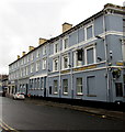
2
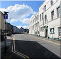
Up North Street, Baneswell, Newport
One-way North Street ascends from Baneswell Road in the Baneswell area of Newport.
Image: © Jaggery
Taken: 14 May 2020
0.01 miles
3
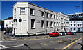
Queens Chambers, North Street, Newport
Office of Harding Evans solicitors.
Image: © Jaggery
Taken: 14 May 2018
0.01 miles
4
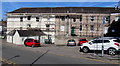
Pump Street scaffolding, Baneswell, Newport
Part of an extensive area of scaffolding which in April 2016
extends around the corner on the left into Baneswell Road. http://www.geograph.org.uk/photo/4904873
Image: © Jaggery
Taken: 12 Apr 2016
0.01 miles
5
Smooth Moves, Baneswell, Newport
Property agents office in Baneswell Road.
Image: © Jaggery
Taken: 27 Apr 2014
0.02 miles
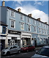
6
Baneswell Road side of the Queen's Hotel, Newport
The mid 19th century building on the corner of Baneswell Road and Bridge Street was Grade II listed in 1980.
http://www.geograph.org.uk/photo/4743885 to a closer view of the Queen Victoria portrait on the name sign.
Image: © Jaggery
Taken: 15 Nov 2015
0.02 miles
7

Haart office, Newport
This is the North Street/Baneswell Road corner of the estate agents' office
at 11 Bridge Street. The entrance is out of shot beyond the tree on the left.
Image: © Jaggery
Taken: 15 Nov 2015
0.02 miles
8
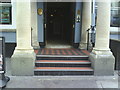
Entrance to The Queens Hotel
A BOGOF offer from the Ordnance Survey? Both pillars at the entrance to the hotel have an Ordnance Survey cut mark benchmark cut into them. For more information on the marks refer to http://www.bench-marks.org.uk/bm35068 and http://www.bench-marks.org.uk/bm35069.
Image: © Roger Templeman
Taken: 5 Aug 2010
0.02 miles
9
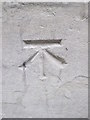
Ordnance Survey Cut Mark
This OS cut mark can be found on the base of the left hand pillar of the porch on the Queen's Hotel. It marks a point 12.084m above mean sea level.
Image: © Adrian Dust
Taken: 25 May 2015
0.02 miles
10
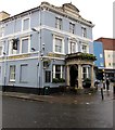
Queen's Hotel entrance, Newport
On the corner of Baneswell Road and Bridge Street. The mid 19th century building was Grade II listed in 1980.
Image: © Jaggery
Taken: 15 Nov 2015
0.02 miles