IMAGES TAKEN NEAR TO
North Street, NEWPORT, NP20 1JZ
Introduction
This page details the photographs taken nearby to North Street, NP20 1JZ by members of the Geograph project.
The Geograph project started in 2005 with the aim of publishing, organising and preserving representative images for every square kilometre of Great Britain, Ireland and the Isle of Man.

There are currently over 7.5m images from over14,400 individuals and you can help contribute to the project by visiting https://www.geograph.org.uk
Image Map
Images are licensed for reuse under creativecommons.org/licenses/by-sa/2.0
Notes
- Clicking on the map will re-center to the selected point.
- The higher the marker number, the further away the image location is from the centre of the postcode.
Image Listing (3338 Images Found)
Images are licensed for reuse under creativecommons.org/licenses/by-sa/2.0
Image
Details
Distance
1
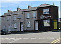
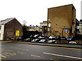
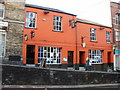
Dutchy's Jamaican Jerk Shack, Baneswell, Newport
Located at 15 North Street, opposite Scard Street. The name is a reference to Jerk Chicken, a Jamaican dish available with different levels of heat (mild, medium, hot or extra hot). A popular dish is curried goat. Jamaican cocktails are available.The door is painted in the yellow and green colours of the national flag of Jamaica.
Image: © Jaggery
Taken: 23 May 2019
0.01 miles
2
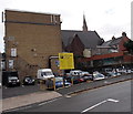
North Street car park, Newport
Run by NCP, the Pay and Display (or Pay by Phone) car park is in the Baneswell area of Newport, on the edge of the city centre.
Image: © Jaggery
Taken: 28 Oct 2013
0.01 miles
3

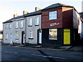
Dutchy's Jamaican Jerk Shack, Newport
Located at 15 North Street, Baneswell, facing Scard Street.
The premises' name is a reference to a Jamaican dish, Jerk Chicken, available with different levels of heat (mild, medium, hot or extra hot). A popular dish is curried goat. Jamaican cocktails are available.
The doorway features the green and yellow colours of the national flag of Jamaica.
The alleyway is Wesley Place, leading to Stow Hill.
Image: © Jaggery
Taken: 28 Oct 2013
0.02 miles
4
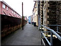
Wesley Place, Newport
Lane extending for 65 metres from Stow Hill (on this side) to North Street.
Image: © Jaggery
Taken: 22 Jan 2015
0.02 miles
5
Dutchy's Jamaican Jerk Shack, Baneswell, Newport
At 15 North Street, facing Scard Street. The doorway is painted in the yellow and green colours of the national flag of Jamaica. The business name is a reference to a Jamaican dish, Jerk Chicken, available with different levels of heat (mild, medium, hot or extra hot). A popular dish is curried goat. Jamaican cocktails are available here.
Image: © Jaggery
Taken: 21 Nov 2015
0.02 miles
6
North Street NCP car park, Baneswell, Newport
Pay and display car park on the east side of North Street.
Founded in 1931, NCP (National Car Parks) is the UK's largest private car park operator.
Image: © Jaggery
Taken: 22 Jan 2015
0.02 miles
7
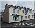
Former Darlows Residential Lettings office to let, Newport
Viewed across North Street in August 2013. I was surprised to see the board of another estate agent on the property, as Darlows have other offices in business. Perhaps the explanation is that Darlows do not handle lettings of business premises?
Image: © Jaggery
Taken: 8 Aug 2013
0.02 miles
8
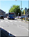
Unusual route for a 151 bus in Newport city centre
The Stagecoach bus from Blackwood to Market Square bus station in Newport is being diverted
via North Street during the temporary closure https://www.geograph.org.uk/photo/5773456 of the northern end of Stow Hill on May 14th 2018.
Image: © Jaggery
Taken: 14 May 2018
0.02 miles
9
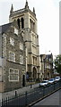
St Mary's RC Church, Stow Hill, Newport
On this site, a small Roman Catholic chapel was built in 1812.
During 1839 the old chapel was demolished and the current church built
in its place, the first in Wales to use metal pillars.
The church opened in 1840.
St Mary's is part of All Saints Parish in the Roman Catholic Archdiocese of Cardiff.
Image: © Jaggery
Taken: 19 Sep 2009
0.02 miles
10
Pen and Wig, Newport
Pub at 22-24 Stow Hill, Newport. The pavements and premises on the western side of Stow Hill are raised several feet above the level of the road, as seen here.
Update January 2014. Now white. http://www.geograph.org.uk/photo/3811938
Image: © Jaggery
Taken: 20 Dec 2009
0.02 miles