IMAGES TAKEN NEAR TO
Wesley Place, NEWPORT, NP20 1JF
Introduction
This page details the photographs taken nearby to Wesley Place, NP20 1JF by members of the Geograph project.
The Geograph project started in 2005 with the aim of publishing, organising and preserving representative images for every square kilometre of Great Britain, Ireland and the Isle of Man.

There are currently over 7.5m images from over14,400 individuals and you can help contribute to the project by visiting https://www.geograph.org.uk
Image Map
Images are licensed for reuse under creativecommons.org/licenses/by-sa/2.0
Notes
- Clicking on the map will re-center to the selected point.
- The higher the marker number, the further away the image location is from the centre of the postcode.
Image Listing (3343 Images Found)
Images are licensed for reuse under creativecommons.org/licenses/by-sa/2.0
Image
Details
Distance
1
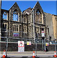
Fenced-off remains of Bethel Community Church, Stow Hill, Newport
Viewed on June 22nd 2018. The South Wales Argus reported that the church was devastated by a fire which spread from the empty former Zanzibar nightclub next door on Friday, June 15th 2018. 83 fire fighters, 10 fire engines, five water bowsers, two aerial ladders, a hydraulic platform, an incident command unit and three supporting appliances battled through the night to bring the blaze under control.
Drone footage shows huge piles of rubble inside the church. The roof has been completely destroyed. The pastor of the church, Andrew Cleverley, has vowed to rebuild. In the meantime the congregation has moved to nearby Havelock Street Presbyterian Church.
After the fire Gwent Police stated that two people were arrested on suspicion of arson.
Image: © Jaggery
Taken: 22 Jun 2018
0.01 miles
2
Benchmark on Bethel Community Church, Stow Hill
Ordnance Survey cut mark benchmark which is described on the Bench Mark Database at http://www.bench-marks.org.uk/bm35075.
Image: © Roger Templeman
Taken: 5 Aug 2010
0.01 miles
3
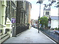
View north along Stow Hill
The view down Stow Hill from outside the Bethel Community Church.
Image: © Roger Templeman
Taken: 5 Aug 2010
0.01 miles
4
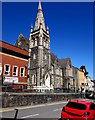
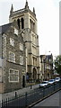
Tower and spire of Bethel Community Church, Stow Hill, Newport
Built in the Decorated Gothic style c1884. Formerly Stow Hill Wesleyan Methodist Church.
Grade II listed in 2000.
Image: © Jaggery
Taken: 14 May 2018
0.01 miles
5
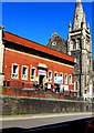
Former Stow Hill public baths, Newport
Stow Hill Baths opened in 1890, built on the site of an old waterworks.
An early photograph shows a building very different from the brick building seen here.
I don't know when the exterior was transformed to its current appearance.
The building has had various uses since the baths closed down. In May 2018,
the name over the entrance is The Gap Centre. A For Sale board is on the wall.
Image: © Jaggery
Taken: 14 May 2018
0.01 miles
6
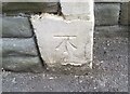
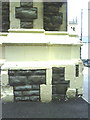
Ordnance Survey Cut Mark
This OS cut mark can be found on the Methodist Church, Stow Hill. It marks a point 23.896m above mean sea level.
Image: © Adrian Dust
Taken: 9 Jun 2018
0.01 miles
7
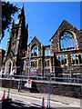
Severely fire-damaged Bethel Community Church, Stow Hill, Newport
Viewed on June 22nd 2018. The South Wales Argus reported that the church was devastated by a fire which spread from the empty former Zanzibar nightclub next door on Friday, June 15th 2018. 83 fire fighters, 10 fire engines, five water bowsers, two aerial ladders, a hydraulic platform, an incident command unit and three supporting appliances battled through the night to bring the blaze under control.
Drone footage shows huge piles of rubble inside the church. The roof has been completely destroyed. The pastor of the church, Andrew Cleverley, has vowed to rebuild. In the meantime the congregation has moved to nearby Havelock Street Presbyterian Church.
After the fire Gwent Police stated that two people were arrested on suspicion of arson.
Image: © Jaggery
Taken: 22 Jun 2018
0.01 miles
8
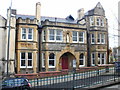
St Mary's RC Church, Stow Hill, Newport
On this site, a small Roman Catholic chapel was built in 1812.
During 1839 the old chapel was demolished and the current church built
in its place, the first in Wales to use metal pillars.
The church opened in 1840.
St Mary's is part of All Saints Parish in the Roman Catholic Archdiocese of Cardiff.
Image: © Jaggery
Taken: 19 Sep 2009
0.01 miles
9
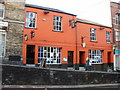
Pen and Wig, Newport
Pub at 22-24 Stow Hill, Newport. The pavements and premises on the western side of Stow Hill are raised several feet above the level of the road, as seen here.
Update January 2014. Now white. http://www.geograph.org.uk/photo/3811938
Image: © Jaggery
Taken: 20 Dec 2009
0.01 miles
10
St Mary's Presbytery, Stow Hill, Newport
The presbytery (priests' house) is located next to St Mary's RC church http://www.geograph.org.uk/photo/1599989 on the east side of Stow Hill, at the corner of School Lane.
Image: © Jaggery
Taken: 20 Dec 2009
0.01 miles