IMAGES TAKEN NEAR TO
High Street, NEWPORT, NP20 1GB
Introduction
This page details the photographs taken nearby to High Street, NP20 1GB by members of the Geograph project.
The Geograph project started in 2005 with the aim of publishing, organising and preserving representative images for every square kilometre of Great Britain, Ireland and the Isle of Man.

There are currently over 7.5m images from over14,400 individuals and you can help contribute to the project by visiting https://www.geograph.org.uk
Image Map
Images are licensed for reuse under creativecommons.org/licenses/by-sa/2.0
Notes
- Clicking on the map will re-center to the selected point.
- The higher the marker number, the further away the image location is from the centre of the postcode.
Image Listing (3183 Images Found)
Images are licensed for reuse under creativecommons.org/licenses/by-sa/2.0
Image
Details
Distance
1
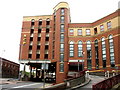
NCP car park building, Queensway, Newport
This multi-storey car park is adjacent to Newport railway station. It has 392 parking spaces.
Image: © Jaggery
Taken: 16 Aug 2009
0.00 miles
2
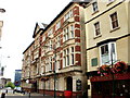
The Kings Hotel, Newport
There has been a hotel on this site, 8 High Street, Newport, for more than 200 years. Formerly known as the King's Head, this is currently The Kings Hotel.
Facilities available include meeting and conference rooms, banqueting and celebration venues, a bar, restaurant, lounge, 24/7 concierge and private parking. The hotel is privately owned.
UPDATE February 2012. The hote is now boarded up and closed. http://www.geograph.org.uk/photo/2816824
Image: © Jaggery
Taken: 16 Aug 2009
0.00 miles
3
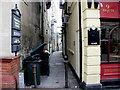
Carpenters Arms Lane, Newport
This very narrow, gloomy lane runs from High Street to Market Street. On the left is the edge of the Kings Hotel http://www.geograph.org.uk/photo/1548272. On the right is the Carpenters pub http://www.geograph.org.uk/photo/1560287
Image: © Jaggery
Taken: 16 Aug 2009
0.00 miles
4
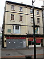
Former Carpenters pub, High Street, Newport
The Carpenters (previously Carpenters Arms) pub is closed and the building sealed. This is how it looked when open for business http://www.geograph.org.uk/photo/782837
4 white notices attached to the metal shuttering declare that all items of value have been removed from the premises.
Update February 2010 : the pub has reopened. http://www.geograph.org.uk/photo/1720388
The large sign on the first floor, above the CA of the pub sign, states
The Carpenters Arms
Without fear of contradiction, The Carpenters Arms
is the oldest public house in Newport.
It was originally built in 1403,
as a meeting place for and by the tradesmen
of whom it is named after.
In addition to storing a fine stock of natural ale,
the cellars also housed those who broke the law.
Short term prisoners would serve their sentences here,
while more serious offenders would be taken
to the county gaol at Monmouth.
Image: © Jaggery
Taken: 25 Oct 2009
0.00 miles
5
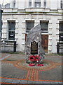
D-Day 50th anniversary plaque, High Street, Newport
Plaque erected in 1994 to commemorate the 50th anniversary of the D-Day landings in Normandy.
http://www.geograph.org.uk/photo/1607064 to a closeup view of the plaque.
Image: © Jaggery
Taken: 5 Dec 2009
0.00 miles
6
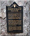
D-Day plaque detail, High Street, Newport
A closeup view of the D-Day plaque http://www.geograph.org.uk/photo/1607056 erected in High Street, Newport.
Image: © Jaggery
Taken: 5 Dec 2009
0.00 miles
7
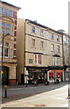
High Street entrance to Market Arcade, Newport
Market Arcade runs from High Street to Market Street.
Image: © Jaggery
Taken: 17 Jan 2010
0.00 miles
8
Reopened Carpenters pub, High Street, Newport
Having been closed and boarded up http://www.geograph.org.uk/photo/1560287 for six months, the historic Newport pub The Carpenters reopened under new management in February 2010. The Carpenters has been bought by pub chain J.W. Bassett Pubs and Bars and has undergone a full refurbishment.
Image: © Jaggery
Taken: 21 Feb 2010
0.00 miles
9
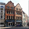
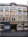
The Page, 14 High Street, Newport
Pub previously named The Front Page.
The top three floors of the building have unusual window frame designs, and there is an elaborate design to the tops of the building. For many decades, from 1897, the building housed the offices of local newspaper the South Wales Argus, now located in the west of the city, in Maesglas. http://www.geograph.org.uk/photo/1925631
Image: © Jaggery
Taken: 21 Feb 2010
0.00 miles
10
The Kings Hotel, Newport viewed from the north east
The Kings Hotel is located at the castle end of High Street.
http://www.geograph.org.uk/photo/1548272 to a view from the opposite direction, and brief history.
Image: © Jaggery
Taken: 11 Apr 2010
0.00 miles