IMAGES TAKEN NEAR TO
Canal Parade, NEWPORT, NP20 1ER
Introduction
This page details the photographs taken nearby to Canal Parade, NP20 1ER by members of the Geograph project.
The Geograph project started in 2005 with the aim of publishing, organising and preserving representative images for every square kilometre of Great Britain, Ireland and the Isle of Man.

There are currently over 7.5m images from over14,400 individuals and you can help contribute to the project by visiting https://www.geograph.org.uk
Image Map
Images are licensed for reuse under creativecommons.org/licenses/by-sa/2.0
Notes
- Clicking on the map will re-center to the selected point.
- The higher the marker number, the further away the image location is from the centre of the postcode.
Image Listing (1370 Images Found)
Images are licensed for reuse under creativecommons.org/licenses/by-sa/2.0
Image
Details
Distance
1
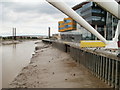
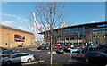
Newport : west bank of the Usk adjacent to new university campus
The view from the Usk footbridge shows the back of the newly-built university building. http://www.geograph.org.uk/photo/1886472
In the distance is George Street Bridge. http://www.geograph.org.uk/photo/1658628
Image: © Jaggery
Taken: 1 Aug 2010
0.01 miles
2
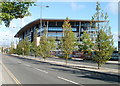
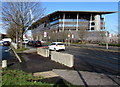
Usk Way, Newport
Looking north along Usk Way (A4042). The large building behind the tree-lined central reservation is the City Centre Campus of the University of Wales, Newport.
Image: © Jaggery
Taken: 12 Sep 2010
0.01 miles
3
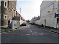
Along Caroline Street, Newport
From Lower Dock Street along Caroline Street towards Canal Parade and Usk Way.
Pegasus https://www.geograph.org.uk/photo/6466180 is on the right.
Image: © Jaggery
Taken: 7 May 2020
0.01 miles
4
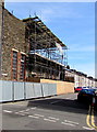
Caroline Street, Newport
From Lower Dock Street along Caroline Street towards Canal Parade and Usk Way.
In July 2017, the scaffolding extends around the corner into Lower Dock Street. http://www.geograph.org.uk/photo/5453203
Image: © Jaggery
Taken: 7 Jul 2017
0.01 miles
5
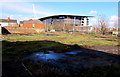
Waste ground on the north side of the Lidl Granville Street supermarket, Newport
Looking towards the A4042 Usk Way and the University of South Wales Newport City Campus building.
The houses on the left are in Caroline Street.
Image: © Jaggery
Taken: 9 Feb 2016
0.02 miles
6
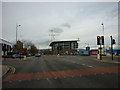
Two concrete blocks at the edge of Usk Way, Newport
Blocking vehicular access to and from Canal Parade and Caroline Street.
The University of South Wales Newport City Campus building is in the background.
Image: © Jaggery
Taken: 9 Feb 2016
0.02 miles
7
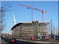
City Centre Campus for the University of Wales, Newport
This £35m project commenced in December 2008 and this view shows the progress one year on.
It will be home to two academic schools, the Newport Business School and part of the Newport School of Art, Media and Design.
For a view of the site in August 2008 see http://www.geograph.org.uk/photo/910068 .
Image: © Robin Drayton
Taken: 1 Jan 2010
0.03 miles
9
Emlyn Street car park, Newport
Owned by Newport City Council, Emlyn Street car park has room for 30 cars.
Image: © Jaggery
Taken: 27 Jan 2013
0.03 miles
10
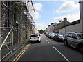
Caroline Street, Newport
Viewed across Lower Dock Street on June 24th 2018.
Scaffolding is on, and temporary fencing is alongside, Abundant Life Centre https://www.geograph.org.uk/photo/5831485
which was damaged by fire three months earlier.
Image: © Jaggery
Taken: 24 Jun 2018
0.03 miles