IMAGES TAKEN NEAR TO
Mellon Street, NEWPORT, NP20 1EP
Introduction
This page details the photographs taken nearby to Mellon Street, NP20 1EP by members of the Geograph project.
The Geograph project started in 2005 with the aim of publishing, organising and preserving representative images for every square kilometre of Great Britain, Ireland and the Isle of Man.

There are currently over 7.5m images from over14,400 individuals and you can help contribute to the project by visiting https://www.geograph.org.uk
Image Map
Images are licensed for reuse under creativecommons.org/licenses/by-sa/2.0
Notes
- Clicking on the map will re-center to the selected point.
- The higher the marker number, the further away the image location is from the centre of the postcode.
Image Listing (1317 Images Found)
Images are licensed for reuse under creativecommons.org/licenses/by-sa/2.0
Image
Details
Distance
1
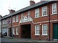
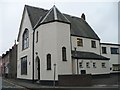
Cooperative Society Buildings, Mellon Street
Through the archway there are some refurbished buildings which are now called Mellon Street Mews.
A book published in 1908 states, "In 1899 the Coop Soc set about the erection of 5 cottages, together with new stables for the accommodation of 12 horses and sheds at the rear for trolleys, wagons and other rolling stock in Mellon Street at a cost of £2775"
Image: © Robin Drayton
Taken: 12 Feb 2010
0.01 miles
2
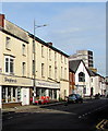
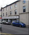
Shepherd's Christian Bookshop, Newport
Viewed across Lower Dock Street in May 2020. Shepherd's Christian Bookshop on the left was previously in the premises next door, now fenced off.
Image: © Jaggery
Taken: 7 May 2020
0.02 miles
3
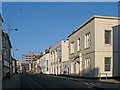
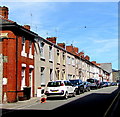
Lower Dock Street, Newport
Taken on New Years Day and unusually devoid of parked cars.
The building in the centre is occupied by King's Church.
In 1850 it was used by a coal proprietor and merchant.
Image: © Robin Drayton
Taken: 1 Jan 2010
0.02 miles
4
Former Cash & Clothes shop, Newport
In early February 2016, To Let boards are on the vacant shop at 130 Lower Dock Street.
Shepherds Christian Bookshop http://www.geograph.org.uk/photo/1597518 is on the right.
Image: © Jaggery
Taken: 9 Feb 2016
0.02 miles
5
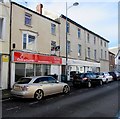
Shepherds Christian Books, Cards, Music & Gifts, Newport
At 131-132 Lower Dock Street.
Image: © Jaggery
Taken: 7 Jul 2017
0.02 miles
6
On-street parking, Mellon Street, Newport
Looking towards Lower Dock Street.
Image: © Jaggery
Taken: 24 Jun 2018
0.02 miles
7
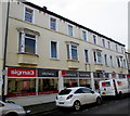
Sigma3 premises and van, Lower Dock Street, Newport
Fitted kitchens, bedrooms and home office showroom at 126 Lower Dock Street.
Image: © Jaggery
Taken: 9 Feb 2016
0.03 miles
8
Powells Place, Newport
Viewed from the wall at the northeast end of Powells Place, looking towards Lower Dock Street.
A Gwent Drug and Alcohol Service office is on the left in the Old School Building. http://www.geograph.org.uk/photo/4822723
Image: © Jaggery
Taken: 9 Feb 2016
0.03 miles
9
Former Ragged School, Lower Dock Street
This former Ragged School (1864) is now used as a clinic.
Image
Image: © Robin Drayton
Taken: 2 Oct 2007
0.03 miles
10
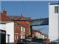
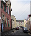
Mellon Street
An overhead walkway connects Image (on the right) to its warehouse. Faded writing on the wall of the warehouse says "Phillips & Sons Ltd. Brewers & Wine Merchants. Stables."
Image: © Robin Drayton
Taken: 31 May 2008
0.03 miles