IMAGES TAKEN NEAR TO
Powells Place, NEWPORT, NP20 1EL
Introduction
This page details the photographs taken nearby to Powells Place, NP20 1EL by members of the Geograph project.
The Geograph project started in 2005 with the aim of publishing, organising and preserving representative images for every square kilometre of Great Britain, Ireland and the Isle of Man.

There are currently over 7.5m images from over14,400 individuals and you can help contribute to the project by visiting https://www.geograph.org.uk
Image Map
Images are licensed for reuse under creativecommons.org/licenses/by-sa/2.0
Notes
- Clicking on the map will re-center to the selected point.
- The higher the marker number, the further away the image location is from the centre of the postcode.
Image Listing (1213 Images Found)
Images are licensed for reuse under creativecommons.org/licenses/by-sa/2.0
Image
Details
Distance
1
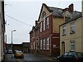
Old School Building, Powells Place
Now housing the Kaleidoscope project which offers a seamless service “one stop shop” approach to substance misuse by catering for medical, social and psychosocial needs.
Image: © Robin Drayton
Taken: 13 Nov 2009
0.01 miles
2
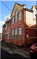
GDAS office, Powells Place, Newport
Located in the Old School Building at the far end of Powells Place,
40 metres east of Lower Dock Street.
The nameboard at the entrance shows GDAS Gwent Drug and Alcohol Service.
Image: © Jaggery
Taken: 9 Feb 2016
0.01 miles
3
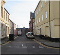
Dead-end Powell's Place, Newport
Powell's Place extends for 50 metres from Lower Dock Street to a high stone wall.
Image: © Jaggery
Taken: 7 May 2020
0.01 miles
4
Corner of Powells Place and Lower Dock Street, Newport
Viewed across Lower Dock Street. Kings Church is on the left.
Image: © Jaggery
Taken: 21 Sep 2014
0.02 miles
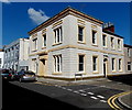
5
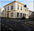
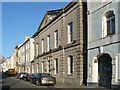
Grade II Listed 69 Lower Dock Street, Newport
The early 19th century building in the Greek Revival style is on the corner of Powell's Place.
Image: © Jaggery
Taken: 7 May 2020
0.02 miles
6
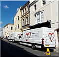
King's Church vans parked in Lower Dock Street, Newport
Viewed on a Sunday while a service was being held at King's Church at the left edge of the view.
Image: © Jaggery
Taken: 21 Sep 2014
0.02 miles
7
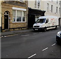
King's Church office and van, Newport
In early May 2020 a King's Church van is parked near the King's Church office at 71 Lower Dock Street.
Image: © Jaggery
Taken: 7 May 2020
0.02 miles
8
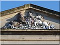
Royal Arms of Queen Victoria on the Old Custom House
http://www.geograph.org.uk/photo/1643133
Image: © Robin Drayton
Taken: 1 Jan 2010
0.02 miles
9
The Old Custom House, Lower Dock Street
Built in 1857 and carrying the Royal Arms of Queen Victoria http://www.geograph.org.uk/photo/1643115 .
For information for the building on the right see http://www.geograph.org.uk/photo/1614309 .
Image: © Robin Drayton
Taken: 1 Jan 2010
0.02 miles
10
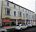
Sigma3 premises and van, Lower Dock Street, Newport
Fitted kitchens, bedrooms and home office showroom at 126 Lower Dock Street.
Image: © Jaggery
Taken: 9 Feb 2016
0.02 miles