IMAGES TAKEN NEAR TO
Henry Wood Walk, NEWPORT, NP19 9SZ
Introduction
This page details the photographs taken nearby to Henry Wood Walk, NP19 9SZ by members of the Geograph project.
The Geograph project started in 2005 with the aim of publishing, organising and preserving representative images for every square kilometre of Great Britain, Ireland and the Isle of Man.

There are currently over 7.5m images from over14,400 individuals and you can help contribute to the project by visiting https://www.geograph.org.uk
Image Map (Loading...)


Getting Data...Please wait
Leaflet Map data © OpenStreetMap
Images are licensed for reuse under creativecommons.org/licenses/by-sa/2.0
Notes
- Clicking on the map will re-center to the selected point.
- The higher the marker number, the further away the image location is from the centre of the postcode.
Image Listing (185 Images Found)
Images are licensed for reuse under creativecommons.org/licenses/by-sa/2.0
Image
Details
Distance
1
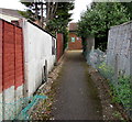
Path to Alway Clinic, Newport
Ascending from Aberthaw Road to this http://www.geograph.org.uk/photo/5063318 building.
Image: © Jaggery
Taken: 2 Jul 2016
0.02 miles
2
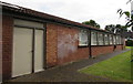
South side of Alway Clinic, Newport
National Health Service Aneurin Bevan Health Board clinic accessed from Aberthaw Road via a 35 metre long path.
Image: © Jaggery
Taken: 2 Jul 2016
0.02 miles
3
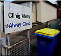
Clinig Alway/Alway Clinic name board, Newport
The bilingual (Welsh/English) board faces Aberthaw Road alongside this http://www.geograph.org.uk/photo/5063321 path to the clinic.
Image: © Jaggery
Taken: 2 Jul 2016
0.04 miles
4
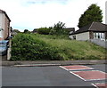
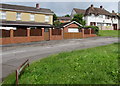
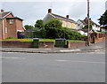
Waste ground on the north side of Aberthaw Road, Newport
The rectangular grassy plot measuring about 35 metres by 15 metres
is between two-storey houses on the left and bungalows on the right.
Image: © Jaggery
Taken: 2 Jul 2016
0.04 miles
5
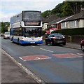
NAT double-decker bus, Aberthaw Road, Alway, Newport
On NAT (New Adventure Travel) route N1 to Spytty Retail Park, also known as Newport Retail Park.
Image: © Jaggery
Taken: 2 Jul 2016
0.04 miles
6
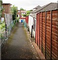
Path descending to Aberthaw Road, Newport
From Alway Clinic. http://www.geograph.org.uk/photo/5063318
Image: © Jaggery
Taken: 2 Jul 2016
0.04 miles
7
Liswerry Road houses, Alway, Newport
North of Aberthaw Road.
Image: © Jaggery
Taken: 2 Jul 2016
0.05 miles
8
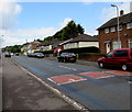
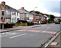
Aberthaw Road speed bumps, Alway, Newport
Viewed from the corner of Liswerry Road.
Aberthaw Road is one of the main roads through Alway and is part of a bus route. http://www.geograph.org.uk/photo/5044594
Image: © Jaggery
Taken: 2 Jul 2016
0.05 miles
9
Telecoms cabinets on an Alway corner, Newport
On the corner of Aberthaw Road and Liswerry Road.
Image: © Jaggery
Taken: 2 Jul 2016
0.05 miles
10
Warning sign - patrol and speed bumps, Aberthaw Road, Newport
On the approach to Alway Primary School.
Image: © Jaggery
Taken: 2 Jul 2016
0.06 miles