IMAGES TAKEN NEAR TO
Elgar Circle, NEWPORT, NP19 9SD
Introduction
This page details the photographs taken nearby to Elgar Circle, NP19 9SD by members of the Geograph project.
The Geograph project started in 2005 with the aim of publishing, organising and preserving representative images for every square kilometre of Great Britain, Ireland and the Isle of Man.

There are currently over 7.5m images from over14,400 individuals and you can help contribute to the project by visiting https://www.geograph.org.uk
Image Map
Images are licensed for reuse under creativecommons.org/licenses/by-sa/2.0
Notes
- Clicking on the map will re-center to the selected point.
- The higher the marker number, the further away the image location is from the centre of the postcode.
Image Listing (79 Images Found)
Images are licensed for reuse under creativecommons.org/licenses/by-sa/2.0
Image
Details
Distance
1
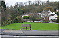
Ladyhill Wood, Newport
Looking towards Ladyhill Wood from Ringwood Avenue. The bench is near the corner of the Dents Hill junction.
Image: © Jaggery
Taken: 16 Nov 2009
0.02 miles
2
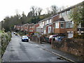
Dents Hill, Newport
Houses on the west side of Dents Hill. Looking towards Ladyhill Wood.
Image: © Jaggery
Taken: 16 Nov 2009
0.02 miles
3
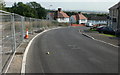
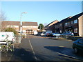
Elgar Circle, Alway
The view midway down Elgar Circle. Behind the fence on the left are house foundations.
Image: © Jaggery
Taken: 10 Sep 2009
0.06 miles
4

Small stone bridge, Dents Hill, Newport
The bridge, across a small unnamed stream, connects the house on the right, Milton http://www.geograph.org.uk/photo/1593706 with the main roadway of Dents Hill.
Image: © Jaggery
Taken: 5 Dec 2010
0.07 miles
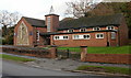
6
Ty Nant, Ringland Circle, Newport
Ty Nant provides a purpose-built supported-living service for six adults in Newport with autism, learning disabilities and challenging behaviour. Each of the tenants has their own flat and use of a shared area for socialising.
Ty Nant uses modern SMART technology, autism-friendly design features and an autism-specific model of care to allow tenants to have more control over their lives.
Image: © Jaggery
Taken: 16 Nov 2009
0.08 miles
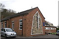
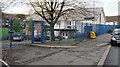
7
Bishpool Methodist, Newport
Located on Ringland Circle, close to the Ringwood Avenue junction. The church opened in 1961.
Image: © Jaggery
Taken: 16 Nov 2009
0.08 miles
8
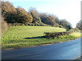
Edge of Ringland Wood, Newport
Viewed across Ringland Circle. The open space at the edge of the wood is immediately south of Bishpool Methodist Church. http://www.geograph.org.uk/photo/1592806
Image: © Jaggery
Taken: 5 Dec 2010
0.10 miles
9
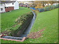
Stream, Ringland Circle, Newport
A stream, running off Dents Hill, flows into a culvert under Ringland Circle.
The stream empties into Liswerry Pill Reen.
Image: © Jaggery
Taken: 16 Nov 2009
0.10 miles
10
Ringwood Place, Newport
Ringwood Place is a cul-de-sac of 14 houses, on the west side of Ringland Circle.
Image: © Jaggery
Taken: 5 Dec 2010
0.10 miles