IMAGES TAKEN NEAR TO
Ladyhill Green, NEWPORT, NP19 9RX
Introduction
This page details the photographs taken nearby to Ladyhill Green, NP19 9RX by members of the Geograph project.
The Geograph project started in 2005 with the aim of publishing, organising and preserving representative images for every square kilometre of Great Britain, Ireland and the Isle of Man.

There are currently over 7.5m images from over14,400 individuals and you can help contribute to the project by visiting https://www.geograph.org.uk
Image Map
Images are licensed for reuse under creativecommons.org/licenses/by-sa/2.0
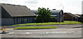
Notes
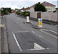
- Clicking on the map will re-center to the selected point.
- The higher the marker number, the further away the image location is from the centre of the postcode.
Image Listing (175 Images Found)
Images are licensed for reuse under creativecommons.org/licenses/by-sa/2.0
Image
Details
Distance
1
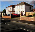
Houses at the eastern end of Liswerry Road, Alway, Newport
Viewed from the corner of Aberthaw Avenue.
Image: © Jaggery
Taken: 29 Jan 2020
0.02 miles
2
Ladyhill Green bungalows, Alway, Newport
The blue railings on the left are at the edge of St Teilo's Church. http://www.geograph.org.uk/photo/5017474
Image: © Jaggery
Taken: 2 Jul 2016
0.03 miles
4
Ladyhill Road, Alway, Newport
The start of Ladyhill Road, at the junction with Liswerry Road, Aberthaw Avenue and Vaughan Williams Drive
Image: © Jaggery
Taken: 20 Aug 2009
0.04 miles
5
St Teilo's Church, Alway , Newport
At the corner of Aberthaw Avenue and Liswerry Road.
Image: © Jaggery
Taken: 20 Aug 2009
0.04 miles
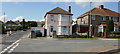
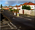
6
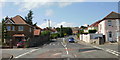
Alway junction, Newport
Ahead is Vaughan Williams Drive; to the left is Liswerry Road; to the right is
Ladyhill Road and behind is Aberthaw Avenue.
Image: © Jaggery
Taken: 20 Aug 2009
0.04 miles
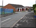
7
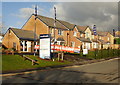
Broadheath, Alway, Newport
Broadheath is Bellway's new housing development of apartments and two, three and four bedroom houses in Alway. Seen here are some of their houses at the lower end of Ladyhill Road, and their sales and information office.
Image: © Jaggery
Taken: 17 Dec 2009
0.04 miles
8
St Teilo's Church Hall, Alway, Newport
Attached to St Teilo's church in the Church in Wales Diocese of Monmouth.
Image: © Jaggery
Taken: 29 Jan 2020
0.04 miles
9
Vaughan Williams Drive speed bump, Alway, Newport
On the approach to a school. A triangular warning sign showing School is ahead.
Image: © Jaggery
Taken: 2 Jul 2016
0.04 miles
10
Vaughan Williams Drive, Alway, Newport
Looking past a speed bump and a pedestrian refuge between Keep Left signs.
Image: © Jaggery
Taken: 29 Jan 2020
0.04 miles