IMAGES TAKEN NEAR TO
Aberthaw Place, NEWPORT, NP19 9PX
Introduction
This page details the photographs taken nearby to Aberthaw Place, NP19 9PX by members of the Geograph project.
The Geograph project started in 2005 with the aim of publishing, organising and preserving representative images for every square kilometre of Great Britain, Ireland and the Isle of Man.

There are currently over 7.5m images from over14,400 individuals and you can help contribute to the project by visiting https://www.geograph.org.uk
Image Map
Images are licensed for reuse under creativecommons.org/licenses/by-sa/2.0
Notes
- Clicking on the map will re-center to the selected point.
- The higher the marker number, the further away the image location is from the centre of the postcode.
Image Listing (188 Images Found)
Images are licensed for reuse under creativecommons.org/licenses/by-sa/2.0
Image
Details
Distance
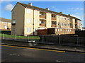
1

Two and three storey housing, Alway, Newport
The edge of the Alway Centre https://www.geograph.org.uk/photo/6379058 is on the left.
Image: © Jaggery
Taken: 29 Jan 2020
0.00 miles
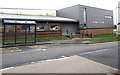
2
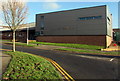
Alway Centre, Aberthaw Avenue, Newport
In January 2020 the green sign on the wall of the Alway Centre shows
Alway Community Centre • Flying Start • Communities First • Newport Youth Service.
Image: © Jaggery
Taken: 29 Jan 2020
0.02 miles
3
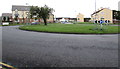
Roundabout in the middle of crossroads, Alway, Newport
The 30 metres diameter roundabout is at the junctions of Aberthaw Avenue
to the north, Balfe Road to the south and Aberthaw Road to the west and east.
Image: © Jaggery
Taken: 2 Jul 2016
0.03 miles
4
Grass roundabout in Alway, Newport
30 metres diameter roundabout in the middle of
the Aberthaw Road/Balfe Road/Aberthaw Avenue crossroads.
Image: © Jaggery
Taken: 29 Jan 2020
0.03 miles
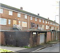
5
Row of three-storey flats, Alway, Newport
The Balfe Road side of flats on the corner of Aberthaw Road.
Image: © Jaggery
Taken: 29 Jan 2020
0.03 miles
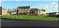
6
Bus stop and shelter outside the Alway Centre, Newport
Viewed across Aberthaw Avenue.
Image: © Jaggery
Taken: 2 Jul 2016
0.04 miles
7
Penkin Hill, Alway, Newport
Houses on the northeast side of Penkin Hill.
Image: © Jaggery
Taken: 17 Dec 2009
0.04 miles
8
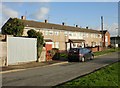
Penkin Close, Alway, Newport
Boarded-up maisonettes destined to be demolished as part of the Alway regeneration scheme.
Image: © Jaggery
Taken: 17 Dec 2009
0.04 miles
9
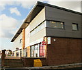
Alway Parade, Newport
This row of shops, Alway Parade, was rebuilt as part of the Alway Regeneration Housing Scheme. Nearest the camera is Alway Pharmacy, which includes Alway Post Office.
Next to the pharmacy is Alway Police Station, officially opened by Prince Edward in September 2009. Vertically side-by-side on the brickwork projecting slightly from the building are the words HEDDLU (Welsh for police) and POLICE.
Image: © Jaggery
Taken: 17 Dec 2009
0.04 miles
10
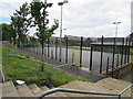
Alway Community Centre sports court, Newport
On the north side of the community centre.
Image: © Jaggery
Taken: 2 Jul 2016
0.04 miles