IMAGES TAKEN NEAR TO
Penkin Close, NEWPORT, NP19 9NT
Introduction
This page details the photographs taken nearby to Penkin Close, NP19 9NT by members of the Geograph project.
The Geograph project started in 2005 with the aim of publishing, organising and preserving representative images for every square kilometre of Great Britain, Ireland and the Isle of Man.

There are currently over 7.5m images from over14,400 individuals and you can help contribute to the project by visiting https://www.geograph.org.uk
Image Map
Images are licensed for reuse under creativecommons.org/licenses/by-sa/2.0
Notes
- Clicking on the map will re-center to the selected point.
- The higher the marker number, the further away the image location is from the centre of the postcode.
Image Listing (162 Images Found)
Images are licensed for reuse under creativecommons.org/licenses/by-sa/2.0
Image
Details
Distance
1
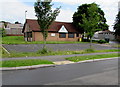
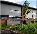
Beechwood Primary Care, Alway, Newport
Medical surgery at 18 Penkin Close, Alway.
Image: © Jaggery
Taken: 2 Jul 2016
0.01 miles
2
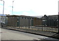
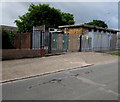
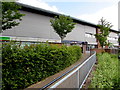
West side of Ringland Primary electricity substation, Alway, Newport
This is the Penkin Close side of the Western Power Distribution primary electricity substation on the corner of Penkin Hill. I was surprised to see that the substation identifier is RINGLAND PRIMARY S/S No 530214, because this location is in Alway, though Ringland is nearby.
Image: © Jaggery
Taken: 2 Jul 2016
0.02 miles
3
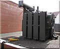
Glimpse inside a primary electricity substation, Alway, Newport
Viewed through the perimeter fence of this http://www.geograph.org.uk/photo/5017351 Western Power Distribution primary electricity substation.
Image: © Jaggery
Taken: 2 Jul 2016
0.02 miles
4
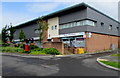
Alway Pharmacy and Post Office, Newport
In 2016, Alway's post office is inside Alway Pharmacy in Alway Parade.
Image: © Jaggery
Taken: 2 Jul 2016
0.03 miles
5
Northeast corner of Ringland Primary electricity substation, Alway, Newport
This is the Penkin Hill side of the large Western Power Distribution electricity substation on the corner of Penkin Close. I was surprised to see that the substation identifier is RINGLAND PRIMARY S/S No 530214, because this location is in Alway, though Ringland is nearby.
Image: © Jaggery
Taken: 2 Jul 2016
0.03 miles
6
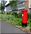
Queen Elizabeth II pillarbox, Alway Parade, Alway, Newport
Located here http://www.geograph.org.uk/photo/5017412 near Alway's post office inside Alway Pharmacy.
Image: © Jaggery
Taken: 2 Jul 2016
0.03 miles
7
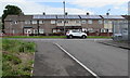
Rooftop solar panels, Penkin Hill, Alway, Newport
Penkin Hill houses viewed from Penkin Close.
Image: © Jaggery
Taken: 2 Jul 2016
0.03 miles
8
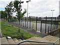
Alway Community Centre sports court, Newport
On the north side of the community centre.
Image: © Jaggery
Taken: 2 Jul 2016
0.04 miles
9
Kasim Take Away and Fish Bar, Alway, Newport
Located at 3 Alway Parade, in the middle of a row of shops. Alway Police Station is on the right.
Image: © Jaggery
Taken: 2 Jul 2016
0.04 miles
10
Path ascending to Alway Parade, Alway, Newport
Towards a row of shops in Alway Parade. Nearest the top of the path
are a William Hill betting shop and Kasim Take Away and Fish Bar. http://www.geograph.org.uk/photo/5017374
Image: © Jaggery
Taken: 2 Jul 2016
0.04 miles