IMAGES TAKEN NEAR TO
Hendre Farm Drive, NEWPORT, NP19 9JL
Introduction
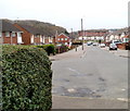
This page details the photographs taken nearby to Hendre Farm Drive, NP19 9JL by members of the Geograph project.
The Geograph project started in 2005 with the aim of publishing, organising and preserving representative images for every square kilometre of Great Britain, Ireland and the Isle of Man.

There are currently over 7.5m images from over14,400 individuals and you can help contribute to the project by visiting https://www.geograph.org.uk
Image Map
Images are licensed for reuse under creativecommons.org/licenses/by-sa/2.0
Notes
- Clicking on the map will re-center to the selected point.
- The higher the marker number, the further away the image location is from the centre of the postcode.
Image Listing (51 Images Found)
Images are licensed for reuse under creativecommons.org/licenses/by-sa/2.0
Image
Details
Distance
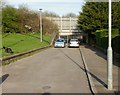
1
Dawson Close, Ringland, Newport
The view west from the edge of an underpass. http://www.geograph.org.uk/photo/1798257 In the distance is Hendre Farm Drive.
Image: © Jaggery
Taken: 26 Nov 2010
0.06 miles
2
Dawson Close underpass viewed from the west
Looking along Dawson Close, Ringland towards the underpass beneath Ringland Way.
A pedestrian gate is open on the right side of the underpass entrance.
The view from the other side of the underpass. http://www.geograph.org.uk/photo/1798255
Image: © Jaggery
Taken: 9 Apr 2010
0.12 miles
3
Moore Crescent, Ringland, Newport
The view south from the corner of Dawson Crescent.
Image: © Jaggery
Taken: 26 Nov 2010
0.12 miles
4
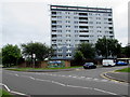
Milton Court, Ringland, Newport
Managed by Newport City Homes, Milton Court is retirement/sheltered housing
containing 82 flats, built in 1987, renovated in 2013, viewed in June 2016.
This photo http://www.geograph.org.uk/photo/1583818 was taken in 2010, before renovation.
Image: © Jaggery
Taken: 22 Jun 2016
0.14 miles
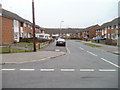
5
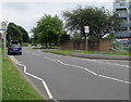
Start of the 20 zone, Hendre Farm Court, Ringland, Newport
The 30mph speed limit drops to 20mph on the approach to schools.
Image: © Jaggery
Taken: 22 Jun 2016
0.14 miles
6
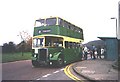
Old Bus at Ringland
Newport's old Leyland Titan calling at Ringland while raising money for the annual Children in Need appeal.
Image: © David Roberts
Taken: Unknown
0.14 miles
7
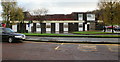
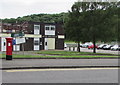
The Friendship Inn, Ringland
Pub located at the Ringland Centre.
Image: © Jaggery
Taken: 15 Nov 2009
0.15 miles
8
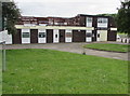
The Friendship, Ringland, Newport
Pub in the Ringland Centre.
Image: © Jaggery
Taken: 22 Jun 2016
0.15 miles
9
The Friendship, Ringland, Newport
Pub located in the Ringland Centre.
Image: © Jaggery
Taken: 22 Jun 2016
0.15 miles
10
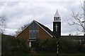
Presbyterian Church, Ringland
Image: © Adrian and Janet Quantock
Taken: 7 Apr 2006
0.16 miles