IMAGES TAKEN NEAR TO
Hendre Farm Gardens, NEWPORT, NP19 9HP
Introduction
This page details the photographs taken nearby to Hendre Farm Gardens, NP19 9HP by members of the Geograph project.
The Geograph project started in 2005 with the aim of publishing, organising and preserving representative images for every square kilometre of Great Britain, Ireland and the Isle of Man.

There are currently over 7.5m images from over14,400 individuals and you can help contribute to the project by visiting https://www.geograph.org.uk
Image Map (Loading...)


Getting Data...Please wait
Leaflet Map data © OpenStreetMap
Images are licensed for reuse under creativecommons.org/licenses/by-sa/2.0
Notes
- Clicking on the map will re-center to the selected point.
- The higher the marker number, the further away the image location is from the centre of the postcode.
Image Listing (42 Images Found)
Images are licensed for reuse under creativecommons.org/licenses/by-sa/2.0
Image
Details
Distance
1
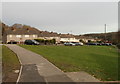
North side of Tallis Close, Newport
Houses built in the 1960s viewed from the corner of Dunstable Road.
Image: © Jaggery
Taken: 26 Nov 2010
0.09 miles
2
Tallis Close, Newport
Viewed across Dunstable Road. Tallis Close has 33 houses, built in the 1960s.
http://www.geograph.org.uk/photo/2175570 to a view of the north side of the close.
Image: © Jaggery
Taken: 26 Nov 2010
0.09 miles
3
Newport : Ringland Primary School viewed from the east
The view along Dunstable Road. The school has about 250 pupils (age range 4 to 11). http://www.geograph.org.uk/photo/2175591 to the view from the west.
Image: © Jaggery
Taken: 26 Nov 2010
0.11 miles
4
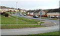
Hendre Farm Drive, Newport
Looking east along Hendre Farm Drive from the southern end of Dunstable Road.
Image: © Jaggery
Taken: 26 Nov 2010
0.11 miles
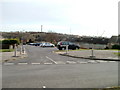
5
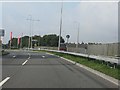
Approaching Hartridge Farm Road roundabout
Seen from Ringland Way, part of the A48 Newport southern bypass.
Image: © J Whatley
Taken: 22 Sep 2010
0.13 miles
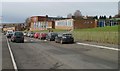
6
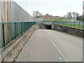
Underpass to Hartridge Farm Road, Newport
A path from Hendre Farm Drive leads to an underpass beneath Ringland Way. In the distance is Hartridge High School.
Image: © Jaggery
Taken: 26 Nov 2010
0.14 miles
7
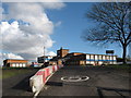
Entrance to Lower School Hartridge High
Image: © Gareth James
Taken: 12 Feb 2011
0.14 miles
8
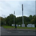
Two phone masts and numerous boxes for electronics
Image: © David Smith
Taken: 28 Sep 2021
0.15 miles
10
The Hendre, Sterndale Bennett Road, Newport
Large house, now divided into six flats, at the corner of Sterndale Bennett Road and Dunstable Road.
Image: © Jaggery
Taken: 26 Nov 2010
0.16 miles