IMAGES TAKEN NEAR TO
Ringwood Place, NEWPORT, NP19 9HJ
Introduction
This page details the photographs taken nearby to Ringwood Place, NP19 9HJ by members of the Geograph project.
The Geograph project started in 2005 with the aim of publishing, organising and preserving representative images for every square kilometre of Great Britain, Ireland and the Isle of Man.

There are currently over 7.5m images from over14,400 individuals and you can help contribute to the project by visiting https://www.geograph.org.uk
Image Map
Images are licensed for reuse under creativecommons.org/licenses/by-sa/2.0
Notes
- Clicking on the map will re-center to the selected point.
- The higher the marker number, the further away the image location is from the centre of the postcode.
Image Listing (43 Images Found)
Images are licensed for reuse under creativecommons.org/licenses/by-sa/2.0
Image
Details
Distance
1
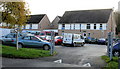
St Gabriel's RC Church, Newport
St Gabriel's Roman Catholic church at 141 Ringland Circle, on the corner of Ringwood Avenue. St Gabriel's RC school is nearby http://www.geograph.org.uk/photo/1593778
Image: © Jaggery
Taken: 16 Nov 2009
0.03 miles
2
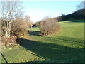
Open space NE of Ringwood Avenue, Newport
A long, narrow strip of sloping open land stretches NE from Ringwood Avenue, near its junction with Ringland Circle. There is a track through the area - a couple of walkers are just visible in the distance.
Image: © Jaggery
Taken: 5 Dec 2010
0.05 miles
3
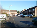
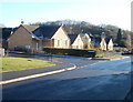
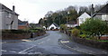
Ringwood Place, Newport
Ringwood Place is a cul-de-sac of 14 houses, on the west side of Ringland Circle.
Image: © Jaggery
Taken: 5 Dec 2010
0.05 miles
4
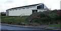
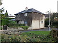
Ringwood House, Dents Hill, Newport
Newport City Council premises. The centre helps people with learning disabilities to get involved in activities and to expand their skills.
Image: © Jaggery
Taken: 16 Nov 2009
0.05 miles
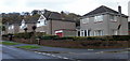
6
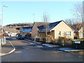
Ringwood Place, Newport
Viewed from Ringland Circle.
Image: © Jaggery
Taken: 16 Nov 2009
0.05 miles
7
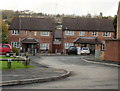
Corner of Bishpool Lane and Bishpool Avenue, Newport
Looking towards bungalows on Bishpool Lane past the turning for Bishpool Avenue.
The modern bungalows replaced prefabs. http://www.geograph.org.uk/photo/1981336
Image: © Jaggery
Taken: 5 Dec 2010
0.06 miles
8
Bishpool Grove, Newport
Viewed from Bishpool Way. Bishpool Grove is at the SE edge of an area of housing that was formerly mostly prefabs. http://www.geograph.org.uk/photo/1981336
Image: © Jaggery
Taken: 5 Dec 2010
0.06 miles
9
Farnaby Close, Newport
Houses were built in the 1960s. Viewed from Ringland Circle.
Image: © Jaggery
Taken: 16 Nov 2009
0.08 miles
10
Ringland Circle,Newport
Houses on the south side of Ringland Circle, between Farnaby Close and Dunstable Road.
Image: © Jaggery
Taken: 16 Nov 2009
0.08 miles