IMAGES TAKEN NEAR TO
Howe Circle, NEWPORT, NP19 9GL
Introduction
This page details the photographs taken nearby to Howe Circle, NP19 9GL by members of the Geograph project.
The Geograph project started in 2005 with the aim of publishing, organising and preserving representative images for every square kilometre of Great Britain, Ireland and the Isle of Man.

There are currently over 7.5m images from over14,400 individuals and you can help contribute to the project by visiting https://www.geograph.org.uk
Image Map
Images are licensed for reuse under creativecommons.org/licenses/by-sa/2.0
Notes
- Clicking on the map will re-center to the selected point.
- The higher the marker number, the further away the image location is from the centre of the postcode.
Image Listing (94 Images Found)
Images are licensed for reuse under creativecommons.org/licenses/by-sa/2.0
Image
Details
Distance
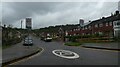
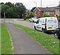
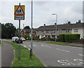
2
Start of the 30 zone, Howe Circle, Ringland, Newport
The 20mph speed limit on Beatty Road near schools increases to 30mph along Howe Circle.
Image: © Jaggery
Taken: 22 Jun 2016
0.07 miles
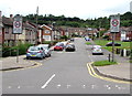
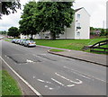
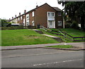
3
Two rows of houses, Ringland, Newport
The row on the left is alongside Beatty Road. The row on the right is alongside Hood Road.
Image: © Jaggery
Taken: 22 Jun 2016
0.07 miles
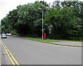
4
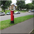
Queen Elizabeth II pillarbox, Beatty Road, Ringland, Newport
Near the Howe Circle junction. http://www.geograph.org.uk/photo/5039280
Image: © Jaggery
Taken: 22 Jun 2016
0.08 miles
5
Shaplands van in Beatty Road, Ringland, Newport
Based in Roath Dock Cargo Terminal in Cardiff, Shaplands are shipwrights and dunnage merchants.
Dunnage is waste material used to secure and protect cargo during transport.
Image: © Jaggery
Taken: 22 Jun 2016
0.08 miles
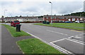
6
Beatty Road speed bumps, Ringland, Newport
On the approach to a school.
Image: © Jaggery
Taken: 22 Jun 2016
0.08 miles
7
Beatty Road southwest of Howe Circle, Ringland, Newport
The trees are at the edge of a small unnamed stream.
Image: © Jaggery
Taken: 22 Jun 2016
0.08 miles
8
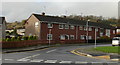
Hood Road, Ringland, Newport
Viewed from Beatty Road.
Image: © Jaggery
Taken: 15 Nov 2009
0.09 miles
9
Steps up from Beatty Road, Ringland, Newport
Towards houses in Jellicoe Close.
Image: © Jaggery
Taken: 22 Jun 2016
0.09 miles
10
Warning sign - patrol, Beatty Road, Ringland, Newport
In the 20mph maximum speed zone on the approach to a school.
Image: © Jaggery
Taken: 22 Jun 2016
0.09 miles