IMAGES TAKEN NEAR TO
Hawke Close, NEWPORT, NP19 9GJ
Introduction
This page details the photographs taken nearby to Hawke Close, NP19 9GJ by members of the Geograph project.
The Geograph project started in 2005 with the aim of publishing, organising and preserving representative images for every square kilometre of Great Britain, Ireland and the Isle of Man.

There are currently over 7.5m images from over14,400 individuals and you can help contribute to the project by visiting https://www.geograph.org.uk
Image Map
Images are licensed for reuse under creativecommons.org/licenses/by-sa/2.0
Notes
- Clicking on the map will re-center to the selected point.
- The higher the marker number, the further away the image location is from the centre of the postcode.
Image Listing (98 Images Found)
Images are licensed for reuse under creativecommons.org/licenses/by-sa/2.0
Image
Details
Distance
1
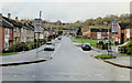
Howe Circle, Ringland, Newport
At first glance, it's strange that this straight road heading away from Beatty Road is named 'Circle'.
Near the houses at the top of the photo, the road bends sharply to the southeast and eventually rejoins Beatty Road near the Ringland Way junction. http://www.geograph.org.uk/photo/1592341 Geometers probably have a word to describe the irregular shape formed by the road, but to the street naming department, 'circle' was close enough.
Image: © Jaggery
Taken: 15 Nov 2009
0.05 miles
3
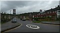
Llanwern Road, Newport
Llanwern Road descends from the B4237 into the Ringland area of Newport.
Multistorey Milton Court http://www.geograph.org.uk/photo/5005186 is in the distance.
Image: © Jaggery
Taken: 22 Jun 2016
0.08 miles
4
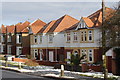
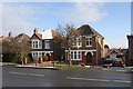
Houses on the B4237, near Coldra, Newport
Interesting to see these two "infill" houses in the context of their older neighbours - they fit in nicely with the row, though with wider frontages, and a quick look on Google Earth confirms them to be considerably bigger in area than the older houses.
Image: © Ruth Sharville
Taken: 3 Feb 2009
0.09 miles
5
Houses on the B4237, near Coldra, Newport
One clearly is better insulated than the other!
Image: © Ruth Sharville
Taken: 3 Feb 2009
0.09 miles
6
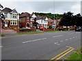
End of the No Parking zone on the B4237, Newport
On the camera side, double yellow lines on both sides of the B4237 indicate no parking at any time.
Ahead, broken white lines mark out parking areas.
Image: © Jaggery
Taken: 22 Jun 2016
0.11 miles
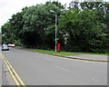
7
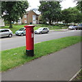
Queen Elizabeth II pillarbox, Beatty Road, Ringland, Newport
Near the Howe Circle junction. http://www.geograph.org.uk/photo/5039280
Image: © Jaggery
Taken: 22 Jun 2016
0.11 miles
8
Beatty Road speed bumps, Ringland, Newport
On the approach to a school.
Image: © Jaggery
Taken: 22 Jun 2016
0.11 miles
9
Beatty Road southwest of Howe Circle, Ringland, Newport
The trees are at the edge of a small unnamed stream.
Image: © Jaggery
Taken: 22 Jun 2016
0.11 miles
10
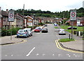
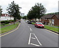
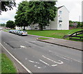
Start of the 30 zone, Howe Circle, Ringland, Newport
The 20mph speed limit on Beatty Road near schools increases to 30mph along Howe Circle.
Image: © Jaggery
Taken: 22 Jun 2016
0.11 miles