IMAGES TAKEN NEAR TO
Bloomfield Close, NEWPORT, NP19 9ET
Introduction
This page details the photographs taken nearby to Bloomfield Close, NP19 9ET by members of the Geograph project.
The Geograph project started in 2005 with the aim of publishing, organising and preserving representative images for every square kilometre of Great Britain, Ireland and the Isle of Man.

There are currently over 7.5m images from over14,400 individuals and you can help contribute to the project by visiting https://www.geograph.org.uk
Image Map
Images are licensed for reuse under creativecommons.org/licenses/by-sa/2.0
Notes
- Clicking on the map will re-center to the selected point.
- The higher the marker number, the further away the image location is from the centre of the postcode.
Image Listing (67 Images Found)
Images are licensed for reuse under creativecommons.org/licenses/by-sa/2.0
Image
Details
Distance
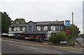
1

ARC Valeting Centre, Chepstow Road, Newport
On the north side of Chepstow Road, close to the Man of Gwent pub.
Image: © Jaggery
Taken: 18 Oct 2009
0.03 miles
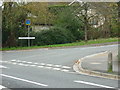
2
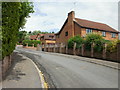
Eisteddfod Walk, Newport
A cul-de-sac of 8 houses connecting with the north side of Chepstow Road. The houses were built in 1988, one of three years that the National Eisteddfod of Wales has been held in Newport.
Image: © Jaggery
Taken: 1 Jul 2010
0.04 miles
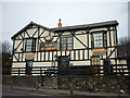
4
The Man of Gwent, Newport
On Chepstow Road.
Image: © JThomas
Taken: 15 Oct 2019
0.05 miles
5

Sign for the Man of Gwent, Newport
See Image] for context.
Image: © JThomas
Taken: 15 Oct 2019
0.06 miles
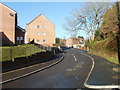
6
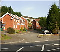
Bloomfield Close, Newport
From Chepstow Road.
Image: © Jaggery
Taken: 18 Oct 2009
0.06 miles
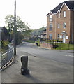
8
Bishpool Lane, Newport
The view north along Bishpool Lane, looking towards Chepstow Road from the corner of Bishpool Way.
Image: © Jaggery
Taken: 5 Dec 2010
0.08 miles
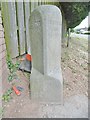
9
Boundary Stone, Bishpool Lane, Newport
Looking along Bishpool Lane from Chepstow Road. The faded boundary stone on the left formerly marked the boundary between Monmouthshire on the left and the County Borough of Newport on the right.
Image: © Jaggery
Taken: 18 Oct 2009
0.08 miles
10
Old Boundary Marker by the B4237, Chepstow Road
Parish Boundary Marker by the B4237 (was A48), in Ringland community (Newport District), Chepstow Road, at junction with Eisteddfod Walk, on verge. MON_NPT01pb is diagonally opposite on the corner of Bishpool Lane: Image
Inscription reads:-
: NEWPORT / BOROUGH : : 1889 : : CHRISTCHURCH / HIGHWAY / DISTRICT :
Surveyed
Milestone Society National ID: MON_NPT02pb
Image: © M Faherty
Taken: Unknown
0.08 miles