IMAGES TAKEN NEAR TO
Kier Hardie Crescent, NEWPORT, NP19 9DQ
Introduction
This page details the photographs taken nearby to Kier Hardie Crescent, NP19 9DQ by members of the Geograph project.
The Geograph project started in 2005 with the aim of publishing, organising and preserving representative images for every square kilometre of Great Britain, Ireland and the Isle of Man.

There are currently over 7.5m images from over14,400 individuals and you can help contribute to the project by visiting https://www.geograph.org.uk
Image Map
Images are licensed for reuse under creativecommons.org/licenses/by-sa/2.0
Notes
- Clicking on the map will re-center to the selected point.
- The higher the marker number, the further away the image location is from the centre of the postcode.
Image Listing (110 Images Found)
Images are licensed for reuse under creativecommons.org/licenses/by-sa/2.0
Image
Details
Distance
1
Tom Mann Close, Newport
Viewed from Kier (an error for Keir) Hardy Crescent.
Tom Mann (1856–1941) was a prominent British trade unionist.
Image: © Jaggery
Taken: 1 Jul 2010
0.01 miles
2
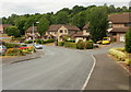
Will Paynter Walk, Newport
Will Paynter Walk extends from the northeast side of William Morris Drive to the edge of George Lansbury Drive. This view is of the William Morris Drive end.
Cardiff-born Will Paynter (1903-1984) was a Welsh miners' leader involved in the hunger marches of the 1930s.
Image: © Jaggery
Taken: 1 Jul 2010
0.07 miles
3

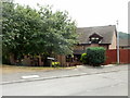
Early Victorian cottage, Royal Oak Hill, Newport
The cottage was built in the 1840s.
The distinctive black and white artwork on the garage door is from a much later era!
Image: © Jaggery
Taken: 16 Oct 2012
0.07 miles
4
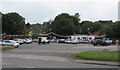
Low Cost Motor Company, Royal Oak, Newport
Set back from the north side of the B4237 Chepstow Road, near an Esso filling station and Tesco Express store.
Image: © Jaggery
Taken: 22 Jun 2016
0.08 miles
5
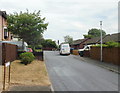
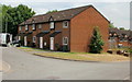
Kier Hardy Crescent, Newport
Houses on the northeast section of Kier (an error for Keir) Hardy Crescent.
On the right is the turning for Fenner Brockway Close.
Image: © Jaggery
Taken: 1 Jul 2010
0.08 miles
6
George Lansbury Drive, Newport
Houses near the Chepstow Road end of George Lansbury Drive.
George Lansbury (1859-1940) was a British MP (1910-1912 and 1922-1940) and leader of the Labour Party from 1932 to 1935. He was a campaigner for social justice and improved living and working conditions, especially in London's East End.
Image: © Jaggery
Taken: 1 Jul 2010
0.08 miles
8
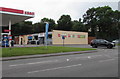
Tesco Chepstow Road Esso Express, Newport
The Tesco Express is located on the east side of an Esso filling station. http://www.geograph.org.uk/photo/5010446
Image: © Jaggery
Taken: 22 Jun 2016
0.09 miles
9
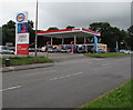
Esso filling station, Chepstow Road, Newport
Viewed across the B4237 Chepstow Road. A Tesco Express store is behind the filling station.
Image: © Jaggery
Taken: 22 Jun 2016
0.09 miles
